Banda Arc
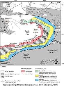
The Banda Arc (main arc, Inner, and Outer) is a set of island arcs that exist in eastern Indonesia. It manifests the collision of a continent and an intra-oceanic island arc. The presently active arc is located on what appears to be oceanic crust whereas the associated subduction trench is underlain by continental crust.[1] The convergence of the Indo-Australian plates and Eurasia and resulted in the formation of the Sunda and Banda island arcs. The transitional zone between the arcs is located south of Flores Island and is characterized by the change in the tectonic regime along the boundary.[2]
Terminology
Some academic literature refers to the arcs by location – so that main arc can be referred to as the 'southern',[3] the 'western' [4] Situated at the centre of three converging and colliding major tectonic plates, Indo-Australia, Eurasia, Pacific, the Banda arc comprises young oceanic crust enclosed by a volcanic inner arc, outer arc islands and a trough parallel to the Australian continental margin. It is a complex subduction setting (where one plate moves under another, sinking into the Earth's mantle), with possibly the largest fold on Earth, extending to a depth of about 650 km (404 mi), in a subducted plate.[5]
Inner/Outer
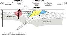
The Banda Arc is a double island arc formed by the collision of the Indo-Australian plate with the Eurasian plate. Principal islands include Timor, Flores, and Seram.
- The Inner Banda Arc consists of a string of recent and active volcanic islands from Komodo to Kekeh-besar of the Barat Daya Islands, including Flores, Solor, Alor, Wetar, and Damar.
- The Outer Banda Arc is older and non-volcanic. It overlies the margin of the Pre-Cambrian craton that makes up much of the continent of Australia. It stretches from Savu through Rote, Timor, Leti, Babar, Tanimbar, and the Kai Islands, before turning west to Seram, Ambon, and Buru. The outer arc is geologically associated with the Australian continent, though it is a more recent accretion than the neighbouring Aru Islands.
The feature they apparently formed is a 180-degree arc, which is more than 1,000 kilometres (620 miles) long. Geographically, it stretches across eastern Indonesia, and is delimited by an active inner volcanic arc. The outer arc contains numerous islands, and its internal structure contains young oceanic crust exclusively.[6]
See also
| Wikibooks has a book on the topic of: The Geology of Indonesia/Banda Arc |
- Banda Sea Plate
- Islands of Indonesia
- Oceanic trench
- Plate tectonic
- Sunda Arc
- Sunda Islands
- Sundaland
- Sunda Trench
- Weber Deep
Notes
- D. J. Whitford; P. A. Jezek (1979). "Origin of late-cenozoic lavas from the Banda arc, Indonesia: Trace element and Sr isotope evidence". Contributions to Mineralogy and Petrology. 68 (2): 141–150. Bibcode:1979CoMP...68..141W. doi:10.1007/BF00371896.
- A. Shulgin; H. Kopp; C. Mueller; E. Lueschen; L. Planert; M. Engels; E. R. Flueh; A. Krabbenhoeft & Y. Djajadihardja (May 27, 2009). "Sunda-Banda arc transition, Incipient continent-island arc collision (northwest Australia)". Geophysical Research Letters. 36 (10): L10304. Bibcode:2009GeoRL..3610304S. doi:10.1029/2009gl037533.
- Ely, Kim Susan (2009), Geochronology of Timor-Leste and seismo-tectonics of the southern Banda Arc, retrieved 21 December 2014
- Chamalaun, F. H; Sunata, Wahyu; Institute for Australasian Geodynamics; Flinders University. School of Earth Sciences; Workshop on Palaeomagnetic Research in Southeast and East Asia (1982 : Kuala Lumpur, Malaysia) (1982), Progress report on the paleomagnetism of the Western Banda Arc system, Institute for Australasian Geodynamics, retrieved 21 December 2014
- University of Royal Holloway London (July 27, 2010). "Indonesia's puzzling Banda arc: New findings explain mystery behind geological development".
- Tudor Vieru (6 Aug 2010). "Origins of the Banda Arc Explained".
References
- Audley-Charles, MG (1986). "Timor–Tanimbar Trough: the foreland basin of the evolving Banda orogen". Spec. Publs Int. Ass. Sediment. 8: 91–102.