Baerami, New South Wales
Baerami is a locality in the Muswellbrook Shire in the Upper Hunter region of New South Wales, Australia.
| Baerami New South Wales | |||||||||||||||
|---|---|---|---|---|---|---|---|---|---|---|---|---|---|---|---|
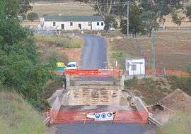 Kirks Bridge and Baerami community hall | |||||||||||||||
Baerami Location in New South Wales | |||||||||||||||
| Coordinates | 32°23′15″S 150°28′05″E | ||||||||||||||
| Postcode(s) | 2333 | ||||||||||||||
| Elevation | 165 m (541 ft)[1] | ||||||||||||||
| Time zone | AEST (UTC+10) | ||||||||||||||
| • Summer (DST) | AEDT (UTC+11) | ||||||||||||||
| Location | |||||||||||||||
| LGA(s) | Muswellbrook Shire | ||||||||||||||
| Region | Upper Hunter | ||||||||||||||
| County | Hunter | ||||||||||||||
| Parish | Baerami | ||||||||||||||
| State electorate(s) | Upper Hunter | ||||||||||||||
| Federal Division(s) | Hunter | ||||||||||||||
| |||||||||||||||
The Bylong Valley Way crosses the Baerami Creek via Kirks Bridge at Baerami. Downstream of the bridge, the creek meets its confluence with the Goulburn River.[2]
The Sandy Hollow-Gulgong goods railway line passes through the locality.
Points of interest include Baerami Community Hall, James Estate, Dingo Gully, and the old Baerami Catholic Church.
See also
References
- "Map of Baerami, NSW". Bonzle Digital Atlas of Australia. Retrieved 15 October 2013.
- "Baerami Creek". Geographical Names Register (GNR) of NSW. Geographical Names Board of New South Wales. Retrieved 15 October 2013.

| Preceding station | NSW Branch lines | Following station | ||
|---|---|---|---|---|
towards Gulgong | Sandy Hollow – Gulgong Line | Sandy Hollow Terminus |
This article is issued from Wikipedia. The text is licensed under Creative Commons - Attribution - Sharealike. Additional terms may apply for the media files.