Babylonian Map of the World
The Babylonian Map of the World (or Imago Mundi) is a Babylonian clay tablet containing a labeled depiction of the known world, with a short and partially lost description, dated to roughly the 6th century BC (Neo-Babylonian or early Achaemenid period).
| Babylonian Map of the World | |
|---|---|
 Obverse | |
| Material | Clay |
| Size | Height: 12.2 cm (4.8 in) Width: 8.2 cm (3.2 in) |
| Writing | cuneiform |
| Created | ~6th century BC |
| Period/culture | Neo-Babylonian / early Achaemenid period |
| Place | Sippar |
| Present location | British Museum, (BM 92687) |
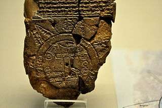
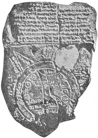
The map is centered on the Euphrates, flowing from the north (top) to the south (bottom). The city of Babylon is shown on the Euphrates, in the northern half of the map. The mouth of the Euphrates is labelled "swamp" and "outflow". Susa, the capital of Elam, is shown to the south, Urartu to the northeast, and Habban, the capital of the Kassites is shown (incorrectly) to the northwest. Mesopotamia is surrounded by a circular "bitter river" or Ocean, and eight "regions", depicted as triangular sections, are shown as lying beyond the Ocean. It has been suggested that the depiction of these "regions" as triangles might indicate that they were imagined as mountains.[1]
The tablet was discovered at Sippar, Baghdad Vilayet, some 60 km north of Babylon on the east bank of the Euphrates River. The text was first translated in 1889.[2] The clay tablet resides at the British Museum (BM 92687).[3]
Description of the mapped areas
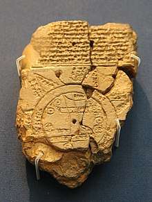
The map is circular with two outer defined circles. Cuneiform script labels all locations inside the circular map, as well as a few regions outside. The two outer circles represent water in between and is labelled as idmaratum "bitter river", the salt sea. Babylon north of center of the map; parallel lines at the bottom seem to represent the southern marshes, and a curved line coming from the north, northeast appear to represent the Zagros Mountains.[4]
There are seven small interior circles at the perimeter areas within the circle, and they appear to represent seven cities. Eight triangular sections on the external circle (water perimeter) represent named "regions" (nagu). The description of five of them has survived.[3]
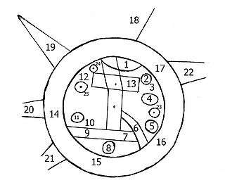 |
1. "Mountain" (Akkadian: šá-du-ú) 2. "City" (Akkadian: uru) 3. Urartu (Akkadian: ú-ra-áš-tu) 4. Assyria (Akkadian: kuraš+šurki) 5. Der (Akkadian: dēr) 6. ? 7. Swamp (Akkadian: ap-pa-ru) 8. Susa (capital of Elam) (Akkadian: šuša) 9. Canal/"outflow" (Akkadian: bit-qu) 10. Bit Yakin (Akkadian: bῑt-ia-᾿-ki-nu) |
11. "City" (Akkadian: uru) 12. Habban (Akkadian: ha-ab-ban) 13. Babylon (Akkadian: tin.tirki), divided by Euphrates 14 – 17. Ocean (salt water, Akkadian: idmar-ra-tum) 18 – 22. outer "regions" (nagu) 23 – 25. No description. |
Carlo Zaccagnini has argued that the design of the Babylonian map of the world may have lived on in the T and O map of the European Middle Ages.[5]
See also
- Babylon
- Sippar
- Cities of the Ancient Near East
- Babylonian astronomy
References
- Lewy H., Lewy J., "The Origin of the Week and the Oldest West Asiatic Calendar", The Hebrew Union College Annual 17 (1943), 1—146.
- F. E. Peiser ZA 4 (1889) 361-370. First publication of a photogaphic reproduction: C. Ball, Light from The East (1899), p. 23.
- British Museum Inv. No.92687.
- Edition of the text: Wayne Horowitz, Mesopotamian Cosmic Geography ch. 2 (1998) [=Iraq 50 (1988), 147-165]. Older editions: F.E. Peier ZA 4 (1889), R.C. Thompson, Cuneiform texts from Babylonian tablets 22 48 (1906), E. Weidner, BoSt 6 (1922) 85-93, E. Unger, Babylon (1931), 254-258.
- Carlo Zaccagnini, ‘Maps of the World’, in Giovanni B. Lanfranchi et al., Leggo! Studies Presented to Frederick Mario Fales on the occasion of his 65th birthday, Wiesbaden, Harrassowitz Verlag, 2012, pp. 865-874.
- Kerrigan, 2009. The Ancients in Their Own Words, Michael Kerrigan, Fall River Press, Amber Books Ltd, c 2009. (hardcover. ISBN 978-1-4351-0724-3)
- Kurt A. Raaflaub & Richard J. A. Talbert (2009), Geography and Ethnography: Perceptions of the World in Pre-Modern Societies, John Wiley & Sons, p. 147, ISBN 1-4051-9146-5
External links
- Full Obverse view, British Museum site
- Full Reverse view, British Museum site
- line drawing, Obverse & Reverse
- British Museum, Map of the World, Photo & Analysis
- Google Arts & Culture – Map of the World from the collection of the British Museum
- Tablet photo, and graphic of map with names
- The Story of Geographical Discovery; Chapter 1, The World as Known to the Ancients, gutenberg.com; Black and White photo, (1.5X)
Gallery
 Map of the World from Sippar, Iraq. 6th century BCE. British Museum
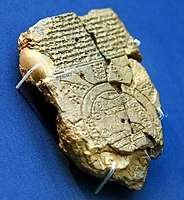 Map of the World from Sippar, Iraq, 6th century BCE. British Museum
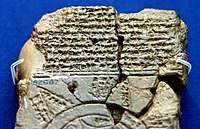 Map of the World from Sippar, Iraq, 6th century BCE. The British Museum