Aylett, Virginia
Aylett is an unincorporated community in King William County, Virginia, United States.[1] It is located where Virginia State Route 360 crosses the Mattaponi River. William Aylett and his family had several prominent warehouses and mills in the area.
Aylett, Virginia | |
|---|---|
 Aylett Location within Virginia and the United States  Aylett Aylett (the United States) | |
| Coordinates: 37°47′9″N 77°6′17″W | |
| Country | United States |
| State | Virginia |
| County | King William |
| Time zone | UTC−5 (Eastern (EST)) |
| • Summer (DST) | UTC−4 (EDT) |
Formerly, Todd's Bridge (no longer in existence), or simply Todd's, was north of Aylett. Todd's and Aylett were both mentioned in Tobacco Inspection Act of 1730 legislation as a location for a public tobacco inspection warehouse.
Later, in 1781, Todd's Bridge provided crossing of the Mattaponi as a part of the Washington–Rochambeau Revolutionary Route [2]
Burlington, Holly Hill, Roseville Plantation, and Zoar are listed on the National Register of Historic Places.[3]
See also
References
- U.S. Geological Survey Geographic Names Information System: Aylett, Virginia
- http://xenophongroup.com/mcjoynt/W-RRREV.htm "After Bolling Green, the route proceeded southeast, and crossed the Mattaponi river at Todds' Bridge [no longer in existence, but located north of locations identified with ‘Aylett' on the southern side of the river]. "
- "National Register Information System". National Register of Historic Places. National Park Service. July 9, 2010.
Municipalities and communities of King William County, Virginia, United States | ||
|---|---|---|
| Town | 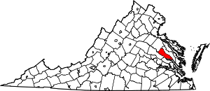 Map of Virginia highlighting King William County | |
| CDPs | ||
| Unincorporated communities |
| |
| Indian reservations | ||
This article is issued from Wikipedia. The text is licensed under Creative Commons - Attribution - Sharealike. Additional terms may apply for the media files.