Aydar Lake
The Aydar Lake (Uzbek: Aydar Ko‘li, Айдар кўли; Haydar ko‘li, Ҳайдар кўли; alternate spellings: Lake Aydarkul, Lake Aidarkul) is part of the man-made Aydar-Arnasay system of lakes, which covers an area of 4,000 square kilometres (1,500 mi2). This system includes 3 brackish water lakes (Aydar Kul, Arnasay and Tuzkan) located in the saline depressions of the south-eastern Kyzyl Kum (now in Uzbekistan and Kazakhstan). The lakes are the unintentional byproduct of Soviet planning.
| Aydar Lake | |
|---|---|
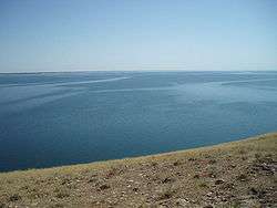 | |
 Aydar Lake | |
| Location | Kyzyl Kum |
| Coordinates | 40°55′00″N 66°48′00″E |
| Lake type | artificial lake |
| Basin countries | Uzbekistan |
| Max. length | 250 km (160 mi) |
| Max. width | 15 km (9.3 mi) |
| Surface area | 3,000 km2 (1,200 sq mi) |
| Water volume | 44.3 km3 (10.6 cu mi) |
| Official name | Aydar-Arnasay Lakes system |
| Designated | 20 October 2008 |
| Reference no. | 1841[1] |
Contribution to the drying up of the Aral Sea
This and many other "unintended" lakes, such as Sarygamysh Lake with the immense capacity of 70 cubic kilometers of water) on the lower Amu Darya, created by the negligent Soviet planners, deny the Aral Sea about 150 cubic kilometers of annual inflow of water, directly contributing to, if not actually causing the latter's drying up.
History of creation
Up to the middle of the last century, the Arnasay lowland remained a dry salt pan during most of the year. Only in Spring, in the lowlands, would the small, ephemeral Lake Tuzkan glisten briefly, disappearing in the hot weather.
In the early sixties the Syr Darya was dammed up. Simultaneously the Chardara Dam was constructed. Floodgates were provided in the dam for flood control, and when in 1969 a raging flood occurred, these were opened as the dam's capacity was inadequate to cope with the flow. Between February 1969 and February 1970 almost 60% of the Syr Darya's average annual water flow (21 km3) was drained from the Chardarya Reservoir into the Arnasay lowland. In such a way new lakes were unintentionally created. Since 1969 the Aydar Lake has regularly received the waters of the Syr Darya River when they overflow the capacity of the Chardarya Reservoir. This has gradually filled up the natural cavity of Arnasay lowland to create the second largest lake in the region (after the remains of the Aral Sea).
In 2005 the Aydar Lake contained 44.3 cubic kilometers of water. Today the area of the Aydar Lake amounts 3,000 km2 (1,200 sq mi). It is nearly 250 km (160 mi) long and up to 15 km (9.3 mi) wide. The mineralization of the water in the Aydar Lake averages only 2 grams per liter (2,000 ppm).
Many sorts of fish including the Sazan (Cyprinus carpio), Pike perch (Stizostedion lucioperca), Bream (Abramis brama), Cat-fish (Silurus glanis), Asp (Aspius aspius), Chehon (Pelecus cultratus), Ophidian fish (Channa argus) were introduced to the lake, which nowadays works as a source of industrial fishing. The lake system provides between 760 and 2,000 tonnes of fish annually (according to statistical data between 1994 and 2001).
In addition to fauna common in the Kyzyl Kum, there are many kinds of water birds migrating from the Aral Sea that make their homes around the lake.
The Aydar Lake is located away from inhabited localities. At the present time, 345 families (approx. 1,760 people) reside near the lake.
The region of the Aydar Lake and adjoining Kyzylkum Desert is an area of great potential for fishing, yurting and camel-back riding tourist activities.
See also
| Wikimedia Commons has media related to Aydar Lake. |
- Kyzyl Kum
- Sarmishsay, ancient monuments of anthropogenic activity
- Tourism in Uzbekistan
References
- "Aydar-Arnasay Lakes system". Ramsar Sites Information Service. Retrieved 25 May 2020.
External links
- Tourism Activities in Yurt Camps at Aydar Kul Lake from Aba Sayyoh
.jpg)