Avondale, Colorado
Avondale is a census-designated place (CDP) in Pueblo County, Colorado, United States. It is part of the Pueblo Metropolitan Statistical Area. The population was 674 at the 2010 census.[3][4] The Avondale Post Office has the ZIP Code 81022.[2]
Avondale, Colorado | |
|---|---|
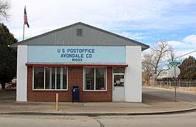 Avondale's post office | |
 Location in Pueblo County and the State of Colorado | |
| Coordinates: 38°14′18″N 104°21′17″W | |
| Country | |
| State | |
| County | Pueblo County |
| Government | |
| • Type | unincorporated community |
| Area | |
| • Total | 3.8 sq mi (9.7 km2) |
| • Land | 3.7 sq mi (9.5 km2) |
| • Water | 0.1 sq mi (0.2 km2) |
| Elevation | 4,557 ft (1,389 m) |
| Population (2010) | |
| • Total | 674 |
| • Density | 198.4/sq mi (77.7/km2) |
| Time zone | UTC-7 (MST) |
| • Summer (DST) | UTC-6 (MDT) |
| ZIP Code | 81022[2] |
| Area code(s) | 719 |
| FIPS code | 08-04165 |
| GNIS feature ID | 0204801 |
A post office called Avondale has been in operation since 1892.[5] The name Avondale is derived from Stratford-upon-Avon.[6]
Geography
Avondale is located at 38°14′18″N 104°21′17″W (38.238376, -104.354748).[7]
According to the United States Census Bureau, the CDP has a total area of 3.8 square miles (9.8 km2), of which, 3.7 square miles (9.6 km2) of it is land and 0.1 square miles (0.26 km2) of it (2.13%) is water.
Demographics
| Historical population | |||
|---|---|---|---|
| Census | Pop. | %± | |
| U.S. Decennial Census[8] | |||
As of the census[4] of 2000, there were 754 people, 251 households, and 200 families residing in the CDP. The population density was 205.2 people per square mile (79.3/km2). There were 276 housing units at an average density of 75.1 per square mile (29.0/km2). The racial makeup of the CDP was 85.01% White, 0.13% African American, 4.11% Native American, 0.13% Asian, 0.13% Pacific Islander, 5.84% from other races, and 4.64% from two or more races. Hispanic or Latino of any race were 64.06% of the population.
There were 251 households, out of which 35.1% had children under the age of 18 living with them, 59.8% were married couples living together, 12.4% had a female householder with no husband present, and 20.3% were non-families. 13.9% of all households were made up of individuals, and 6.0% had someone living alone who was 65 years of age or older. The average household size was 3.00 and the average family size was 3.31.
In the CDP, the population was spread out, with 27.5% under the age of 18, 10.5% from 18 to 24, 22.5% from 25 to 44, 23.9% from 45 to 64, and 15.6% who were 65 years of age or older. The median age was 37 years. For every 100 females, there were 107.1 males. For every 100 females age 18 and over, there were 104.9 males.
The median income for a household in the CDP was $33,229, and the median income for a family was $31,071. Males had a median income of $28,750 versus $24,750 for females. The per capita income for the CDP was $10,529. About 12.3% of families and 13.6% of the population were below the poverty line, including 9.7% of those under age 18 and 23.9% of those age 65 or over.
See also
- Outline of Colorado
- State of Colorado
- Colorado cities and towns
- Colorado census designated places
- Colorado counties
- Colorado metropolitan areas
- Front Range Urban Corridor
- South Central Colorado Urban Area
- Pueblo, CO Metropolitan Statistical Area
- Colorado cities and towns
References
- "US Board on Geographic Names". United States Geological Survey. 2007-10-25. Retrieved 2008-01-31.
- "ZIP Code Lookup". United States Postal Service. December 14, 2006. Archived from the original (JavaScript/HTML) on 14 December 2006. Retrieved December 14, 2006.
- Colorado Trend Report 2: State and Complete Places (Sub-state 2010 Census Data). Archived 2012-07-11 at Archive.today Missouri Census Data Center. Accessed 2011-02-25.
- "U.S. Census website". United States Census Bureau. Retrieved 2008-01-31.
- "Post offices". Jim Forte Postal History. Archived from the original on 6 March 2016. Retrieved 22 June 2016.
- Dawson, John Frank (1954). Place names in Colorado: why 700 communities were so named, 150 of Spanish or Indian origin. Denver, CO: The J. Frank Dawson Publishing Co. p. 8.
- "US Gazetteer files: 2010, 2000, and 1990". United States Census Bureau. 2011-02-12. Retrieved 2011-04-23.
- "Census of Population and Housing". Census.gov. Retrieved June 4, 2016.
External links
| Wikimedia Commons has media related to Avondale, Colorado. |
Municipalities and communities of Pueblo County, Colorado, United States | ||
|---|---|---|
| City | 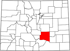 Map of Colorado highlighting Pueblo County | |
| Towns | ||
| CDPs | ||
| Unincorporated communities | ||
| Ghost towns | ||