Averys Gore, Vermont
Averys Gore (or Avery's Gore) is a gore located in Essex County, Vermont, United States.
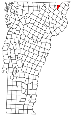
It is one of at least five locations in Vermont known as Averys Gore (or Avery's Gore), the others being located in Addison County, Chittenden County, Franklin County, and Windham County.[1] This page deals specifically with the location in Essex County.
In Vermont, gores and grants are unincorporated portions of a county which are not part of any town and have limited self-government (if any, as some are uninhabited). The population was 0 at the 2010 census.[2] However, the gore does have a few hundred feet of dirt road and one building or structure, on the North Branch of the Nulhegan River by the Lewis town line. More prominently, Gore Mountain, one of the 50 highest in the state, is in the eastern portion of Averys Gore.
History and name
Averys Gore is named for Samuel Avery, a Westminster deputy sheriff and jailkeeper. Avery received roughly 52,000 acres (21,000 ha) in eight separate gores and grants in the 1790s as compensation for land he had owned in a part of the state previously claimed by New York.
The original charter (as reproduced in State Papers of Vermont, Volume Two: Charters Granted by the State of Vermont, VT Secretary of State, 1922, pp 9–11) merely mentions the boundaries of the tract of land, along with two others included in the same charter, granting them to Samuel Avery, but not mentioning any names for the tracts of land. State Papers of Vermont, Volume One: Index to the Papers of the Surveyors-General (VT Secretary of State, 1918) lists all the gores granted to Samuel Avery collectively as "Avery's Gores (Alias Vermont Grants to Samuel Avery)" (p. 31).
While State of Vermont records seem to have consistently used the apostrophe, including state statutes (Title 17, Chapter 34, Section 1893, T. 24, Ch. 1, Sec. 6, and T. 24, Ch. 117, Sec. 4341(e)), the U.S. Board on Geographic Names eschews the use of apostrophes in geographic names, which may improperly imply personal possession.[3] This has led to the use of both spellings. The apostrophe is omitted in Vermont Place-Names: Footprints of History by Esther M. Swift (The Stephen Greene Press, 1977, pp 198–9), in the Vermont Atlas and Gazetteer (Delorme, 9th ed., 1996, p. 55).
Geography
According to the United States Census Bureau, the gore has a total area of 17.6 square miles (45.5 km2), of which 0.035 square miles (0.09 km2), or 0.19%, is water.[2] The north side of the gore drains via several brooks into the Coaticook River, part of the St. Lawrence River basin, while the rest of the gore drains south via the North Branch of the Nulhegan River or the Black Branch of the Nulhegan and is part of the Connecticut River basin.
Demographics
As of the 2010 census,[4] there are no people living in the gore.
References
- Vermont Agency of Administration, Public Records Division. "Localities in Vermont". Retrieved February 25, 2014
- "Geographic Identifiers: 2010 Census Summary File 1 (G001): Avery's gore, Essex County, Vermont". American Factfinder. U.S. Census Bureau. Archived from the original on February 13, 2020. Retrieved April 8, 2016.
- "How Do I?". www.usgs.gov. Retrieved 2020-01-08.
- "American FactFinder". United States Census Bureau. Archived from the original on 2020-02-13. Retrieved 2017-09-26.
Municipalities and communities of Essex County, Vermont, United States | ||
|---|---|---|
Shire town: Guildhall | ||
| Towns | 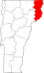 Map of Vermont highlighting Essex County | |
| CDPs | ||
| Grants and gores | ||
| Other communities | ||
| Footnotes | ‡ Unorganized | |