Attu Station, Alaska
Attu Station is a census-designated place (CDP) located on Attu Island in the Aleutians West Census Area in the U.S. state of Alaska. The population was 21 at the 2010 census,[2] consisting entirely of coast guard personnel who resided and worked at Casco Cove Coast Guard Station, but left the island when the station was closed in August 2010, leaving it uninhabited. LORAN Station Attu had provided a navigational signal for mariners of the North Pacific since the 1970s.[2][3][4]
Attu Station, Alaska | |
|---|---|
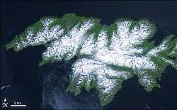 Attu Island with land area of 892.795 km² (344.71 sq mi) | |
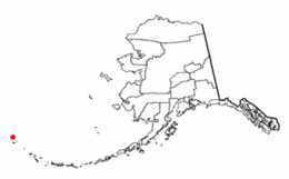 Location of Attu Station, Alaska | |
| Coordinates: 52°50′47″N 173°11′10″E | |
| Country | United States |
| State | Alaska |
| Census Area | Aleutians West |
| Government | |
| • State senator | Lyman Hoffman (D-C)[1] |
| • State rep. | Bryce Edgmon (I) |
| Area | |
| • Total | 143.6 sq mi (372.1 km2) |
| • Land | 142.6 sq mi (369.3 km2) |
| • Water | 1.1 sq mi (2.8 km2) |
| Population (2010) | |
| • Total | 0 |
| Time zone | UTC-10 (Hawaii-Aleutian (HST)) |
| • Summer (DST) | UTC-9 (HDT) |
| Area code(s) | 907 |
| FIPS code | 02-04670 |
Although often considered the westernmost place in the United States due to its location relative to the rest of the country, Attu Station is actually one of the easternmost points in the United States, located at 52°50′47″N 173°11′10″E, on the opposite side of the 180th meridian from the rest of the United States (See Extreme Points of the United States, even though Attu is not listed there.) . Attu Station is so far east that it's only 55 miles away from the border of Russia.[5]
History
After the Japanese invasion of Attu Island and the battle to retake it, the United States government constructed a LORAN station on the southern tip of the island, at Theodore Point. The equipment to build the station came from Holtz Bay and was ferried on barges and landing craft to Baxter Cove, about one mile (1.6 km) east of the station. Bulldozers were used to cut a road from Baxter Cove to Theodore Point.
In 1960 the station was moved to Casco Cove, near the former United States Navy base at Massacre Bay. Later it was moved to Massacre Bay. LORAN Station Attu ceased transmission of the LORAN signal on February 8, 2010 and the Russian-American signal ceased on August 1, 2010.
Geography
According to the U.S. Census Bureau, the CDP has a total area of 143.6 square miles (371.9 km2). 142.6 square miles (369.3 km2) of it is land and 1.1 square miles (2.8 km2) of it (0.75%) is water.
Demographics
| Historical population | |||
|---|---|---|---|
| Census | Pop. | %± | |
| 1980 | 28 | — | |
| 2000 | 20 | — | |
| 2010 | 21 | 5.0% | |
| Est. 2017 | 0 | [6] | −100.0% |
| U.S. Decennial Census[7] | |||
Attu (Naval) Station first appeared on the 1980 U.S. Census as "Attu", a census-designated place (CDP).[8] It did not return on the 1990 census.[9] The name was changed to Attu Naval Station and redesignated a CDP in 2000.[10] It appeared lastly on the 2010 census,[11] just before the closure of the station in August that year and the departure of its remaining residents.
At the 2000 census there were 20 people, 0 households, and 0 families in the CDP. The population density was 0.1 inhabitants per square mile (0.039/km2). There were 0 housing units at an average density of 0.0 per square mile (0/km2). The racial makeup of the CDP was 18 White, 1 from other races, and 1 from two or more races. Five of the population were Hispanic or Latino of any race.[2] The age distribution was 7 from 18 to 24, 12 from 25 to 44, and 1 from 45 to 64. The median age was 30 years. There were 19 men and one woman.
Males had a median income of $26,250, which is the same as for females. The per capita income for the CDP was $26,964. None of the population was below the poverty line.
As noted above, however, due to the closure of the station the community is presently uninhabited.
References
- "Senator Lyman Hoffman". Alaska Senate Majority. Alaskasenate.org. Retrieved November 16, 2019.
- "U.S. Census website". United States Census Bureau. Retrieved 2008-01-31.
- Home page for USCG Loran Station Attu (modified 7/23/2007)
- "Alaska Coast Guard says goodbye to its last LORAN station". KUCB News. Unalaska Community Broadcasting. August 27, 2010. Archived from the original on November 19, 2018. Retrieved March 25, 2013.
- https://slate.com/news-and-politics/2008/09/can-you-really-see-russia-from-alaska.html
- "Population and Housing Unit Estimates". Retrieved June 9, 2017.
- "Census of Population and Housing". Census.gov. Retrieved June 4, 2015.
- https://www2.census.gov/prod2/decennial/documents/1980a_akABCD-01.pdf
- https://www.census.gov/prod/cen1990/cph5/cph-5-3.pdf
- https://www.census.gov/prod/cen2000/phc-1-3.pdf
- https://www.census.gov/prod/cen2010/cph-1-3.pdf
External links
- Attu Station at the Community Database Online from the Alaska Division of Community and Regional Affairs
- Maps from the Alaska Department of Labor and Workforce Development: 2000, 2010
Municipalities and communities of Aleutians West Census Area, Alaska, United States | ||
|---|---|---|
| Cities |  Aleutians West Census Area map | |
| CDPs | ||