Arta Region
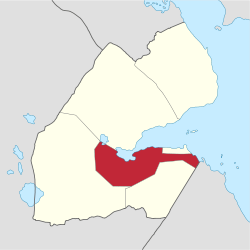
Arta Region (Arabic: إقليم عرتا, Somali: Gobolka Carta) is one of the six regions of Djibouti. It is situated in the south-central of the country, bordering the Tadjoura Region to the north, and the Djibouti Region to the north-east, and Dikhil Region the Ali Sabieh Region to the south, the country of Somalia lies to the east.
Arta Region Gobolka Carta إقليم عرتا | |
|---|---|
 | |
| Country | |
| Administrative centre | Arta |
| Area | |
| • Total | 1,800 km2 (700 sq mi) |
| Population (2019) | |
| • Total | 50,017[1] |
| Time zone | UTC+3 (EAT) |
| ISO 3166 code | DJ-AR |
The capital of Arta Region is Arta. Other towns include We`a, Damerjog and Loyada. The Hemed mountain is the highest point in the region of Arta.
History
Nomadic life in the Arta Region dates back at least 2,000 years. During the Middle Ages, the Arta Region was ruled by the Ifat Sultanate and the Adal Sultanate. It later formed a part of the French Somaliland protectorate in the first half of the 20th century. Loyada village has a beautiful beach and a picturesque palm grove and the tombs of great historical leaders of this region. Halfway between Loyada and Djibouti, the small village of Damerjog and gardens with traditional irrigation systems. The Region of Arta is situated at the boundary of the Afar and Issa Somali sociolinguistic groups.
Overview

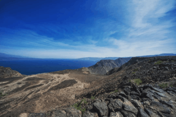
This region has an area of around 1,800 square kilometers. According to the 2009 Census, the local population consists of 42,380 individuals, 17,775 of whom are nomads. Arta was established after the end of the Djiboutian Civil War in 1994. In 2000, peace talks between various factions of the Somali Civil War were held in Arta city, resulting in the establishment of the Transitional National Government of Somalia. The Region's coast is noted for its marine life, including like turtles, dolphins, whale sharks, manta rays, giant grouper, blue spotted rays and other varieties of sharks. Located on the heights of the Arta mountains, more than 700 meters, Arta has a mild climate and is located approximately 20 minutes from Djibouti city with views of the Gulf of Tadjoura.
Climate
The climate of Arta Region is generally semi-arid to arid, and its territory is mostly covered by mountains, high plains, and desert. The climate of the coastal strip is influenced by warm ocean waters, keeping the region free from extremes of temperature and providing moisture for rainfall. However, most of the Arta Region populace experience two weather seasons: a "winter" period of rather cold and warm temperatures and higher levels of rainfall and a sultry summer period of hot, sticky temperatures.
The annual mean statistics for some Arta Region centres is shown below:
| Town | Min. Temp | Max. Temp | Rainfall |
|---|---|---|---|
| Arta | 15.9 °C (60.6 °F) | 37.1 °C (98.8 °F) | 236 mm (9.3 in) |
| We`a | 16.8 °C (62.2 °F) | 38.4 °C (101.1 °F) | 200 mm (7.9 in) |
| Loyada | 20.5 °C (68.9 °F) | 40.5 °C (104.9 °F) | 163 mm (6.4 in) |
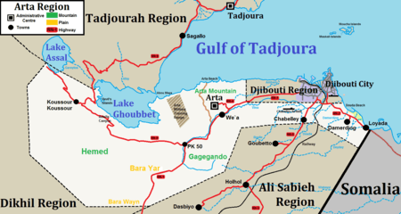
Towns
| Town names | Population |
|---|---|
| Arta | 13,010 |
| We`a | 4,667 |
| Loyada | 1,367 |
| Chabelley | 1,011 |
| Damerjog | 1,321 |
| Koussour | 170 |
References
- "Djibouti Population". presidence.dj. Retrieved 2 February 2020.
- "Djibouti". World Factbook. Central Intelligence Agency. 2007-09-06. Archived from the original on 11 September 2007. Retrieved 2007-09-18.