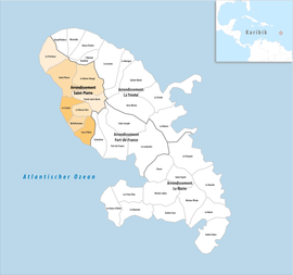
Arrondissement of Saint-Pierre, Martinique
The arrondissement of Saint-Pierre is an arrondissement of France in the Martinique department in the Martinique region. It has eight communes.[1] Its population is 22,926 (2016), and its area is 210.3 km2 (81.2 sq mi).[2]
Saint-Pierre | |
|---|---|
 Location within the region Martinique | |
| Country | France |
| Overseas region and department | Martinique |
| No. of communes | 8 |
| Subprefecture | Saint-Pierre |
| Area | |
| • Total | 210.3 km2 (81.2 sq mi) |
| Population (2016) | |
| • Total | 22,926 |
| • Density | 109/km2 (280/sq mi) |
| INSEE code | 9724 |
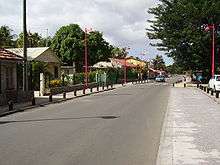
Le Carbet, Saint-Pierre
Composition
The communes of the arrondissement of Saint-Pierre, and their INSEE codes, are:[1]
- Bellefontaine (97234)
- Le Carbet (97204)
- Case-Pilote (97205)
- Fonds-Saint-Denis (97208)
- Le Morne-Rouge (97218)
- Le Morne-Vert (97233)
- Le Prêcheur (97219)
- Saint-Pierre (97225)
History
The arrondissement of Saint-Pierre, containing eight communes that were previously part of the arrondissement of Fort-de-France, was created in 1995.[3]
Before 2015, the arrondissements of Martinique were subdivided into cantons. The cantons of the arrondissement of Saint-Pierre were, as of January 2015:[4]
References
- "Arrondissement de Saint-Pierre (9724)". INSEE. Retrieved 2019-10-06.
- "Comparateur de territoire, géographie au 01/01/2019". INSEE. Retrieved 2019-10-06.
- Décret no 95-725 du 9 mai 1995
- "Populations légales 2012" (PDF). INSEE. December 2014. Retrieved 2019-10-06.
This article is issued from Wikipedia. The text is licensed under Creative Commons - Attribution - Sharealike. Additional terms may apply for the media files.