Arrondissement of Château-Gontier
The arrondissement of Château-Gontier is an arrondissement of France in the Mayenne department in the Pays de la Loire region. It has 76 communes.[1] Its population is 73,769 (2016), and its area is 1,527.4 km2 (589.7 sq mi).[2]
Château-Gontier | |
|---|---|
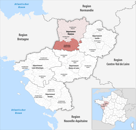 Location within the region Pays de la Loire | |
| Country | France |
| Region | Pays de la Loire |
| Department | Mayenne |
| No. of communes | 76 |
| Subprefecture | Château-Gontier-sur-Mayenne |
| Area | |
| • Total | 1,527.4 km2 (589.7 sq mi) |
| Population (2016) | |
| • Total | 73,769 |
| • Density | 48/km2 (120/sq mi) |
| INSEE code | 531 |
Composition
The communes of the arrondissement of Château-Gontier, and their INSEE codes, are:[1]
- Arquenay (53009)
- Astillé (53011)
- Athée (53012)
- Ballots (53018)
- Bannes (53019)
- La Bazouge-de-Chemeré (53022)
- Bazougers (53025)
- Beaumont-Pied-de-Bœuf (53027)
- Bierné-les-Villages (53029)
- Le Bignon-du-Maine (53030)
- La Boissière (53033)
- Bouchamps-lès-Craon (53035)
- Bouère (53036)
- Bouessay (53037)
- Brains-sur-les-Marches (53041)
- Le Buret (53046)
- La Chapelle-Craonnaise (53058)
- Château-Gontier-sur-Mayenne (53062)
- Châtelain (53063)
- Chemazé (53066)
- Chémeré-le-Roi (53067)
- Chérancé (53068)
- Congrier (53073)
- Cosmes (53075)
- Cossé-en-Champagne (53076)
- Cossé-le-Vivien (53077)
- Coudray (53078)
- Courbeveille (53082)
- Craon (53084)
- La Cropte (53087)
- Cuillé (53088)
- Daon (53089)
- Denazé (53090)
- Fontaine-Couverte (53098)
- Fromentières (53101)
- Gastines (53102)
- Gennes-Longuefuye (53104)
- Grez-en-Bouère (53110)
- Houssay (53117)
- Laubrières (53128)
- Livré-la-Touche (53135)
- Maisoncelles-du-Maine (53143)
- Marigné-Peuton (53145)
- Mée (53148)
- Ménil (53150)
- Méral (53151)
- Meslay-du-Maine (53152)
- Niafles (53165)
- Origné (53172)
- Peuton (53178)
- Pommerieux (53180)
- Préaux (53184)
- Prée-d'Anjou (53124)
- Quelaines-Saint-Gault (53186)
- Renazé (53188)
- La Roche-Neuville (53136)
- La Roë (53191)
- La Rouaudière (53192)
- Ruillé-Froid-Fonds (53193)
- Saint-Aignan-sur-Roë (53197)
- Saint-Brice (53203)
- Saint-Charles-la-Forêt (53206)
- Saint-Denis-d'Anjou (53210)
- Saint-Denis-du-Maine (53212)
- Saint-Erblon (53214)
- Saint-Loup-du-Dorat (53233)
- Saint-Martin-du-Limet (53240)
- Saint-Michel-de-la-Roë (53242)
- Saint-Poix (53250)
- Saint-Quentin-les-Anges (53251)
- Saint-Saturnin-du-Limet (53253)
- La Selle-Craonnaise (53258)
- Senonnes (53259)
- Simplé (53260)
- Val-du-Maine (53017)
- Villiers-Charlemagne (53273)
History
The arrondissement of Château-Gontier was created in 1800, disbanded in 1926 and restored in 1942.[3] At the March 2016 reorganisation of the arrondissements of Mayenne, it gained 14 communes from the arrondissement of Laval.[4]
As a result of the reorganisation of the cantons of France which came into effect in 2015, the borders of the cantons are no longer related to the borders of the arrondissements. The cantons of the arrondissement of Château-Gontier were, as of January 2015:[5]
- Bierné
- Château-Gontier-Est
- Château-Gontier-Ouest
- Cossé-le-Vivien
- Craon
- Grez-en-Bouère
- Saint-Aignan-sur-Roë
References
- "Arrondissement de Château-Gontier (531)". INSEE. Retrieved 2019-10-01.
- "Comparateur de territoire, géographie au 01/01/2019". INSEE. Retrieved 2019-10-01.
- Historique de la Mayenne
- "Arrêté préfectoral, 24 March 2016" (PDF). Retrieved 2019-10-22.
- "Populations légales 2012" (PDF). INSEE. December 2014. Retrieved 2019-10-22.