Arizona State Route 387
State Route 387, also known as SR 387, is a state highway in south-central Arizona, United States traveling from State Route 87 west of Coolidge west to Interstate 10, then south to its junction with State Route 84 and State Route 287 in Casa Grande.
| ||||
|---|---|---|---|---|
 | ||||
| Route information | ||||
| Maintained by ADOT | ||||
| Length | 15.71 mi[1] (25.28 km) | |||
| Existed | 1967–present | |||
| Major junctions | ||||
| South end | ||||
| East end | ||||
| Highway system | ||||
| ||||

Route description
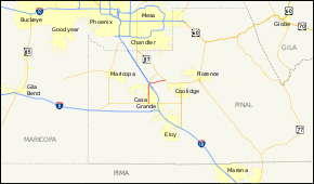
SR 387 is a 15.71-mile (25.28 km) highway that connects Casa Grande with I-10 and SR 87. The southern terminus of the highway is located at an intersection with SR 84 and SR 287 in Casa Grande. It heads north through the city from this intersection to the Gila River Indian Reservation before reaching I-10. After the interchange with I-10, the highway intersects SR 187, with SR 387 turning towards the east at the intersection. The highway continues to the east-northeast until it reaches its northern terminus at SR 87.[1][2]
History
The route was established between 1946 and 1951, from SR 187 to SR 87 just south of Sun Lakes. Between 1958 and 1961, it was cancelled, and became part of SR 93, a proposed extension of US 93. In 1967, SR 387 was designated from SR 93 to SR 87. It extended south over part of SR 93 on December 17, 1984.[3]
Junction list
The entire route is in Pinal County.
| Location | mi[1] | km | Destinations | Notes | |
|---|---|---|---|---|---|
| Casa Grande | 0.00 | 0.00 | Southern terminus of SR 387; eastern terminus of SR 84, western terminus of SR 287; road continues east as 2nd Street | ||
| Gila River Indian Community | 8.56 | 13.78 | Exit 185 on I-10 | ||
| 8.79 | 14.15 | Southern terminus of SR 187 | |||
| 15.71 | 25.28 | Northern terminus | |||
| 1.000 mi = 1.609 km; 1.000 km = 0.621 mi | |||||
References
- Arizona Department of Transportation. "2008 ADOT Highway Log" (PDF). Retrieved April 8, 2008.
- Google. "overview map of SR 387" (Map). Google Maps. Google.
- "Right-of-Way Resolution 1967--018". Arizona Department of Transportation. 1967. Retrieved May 15, 2011.