Areimeh
Areimeh or Uraymah (Arabic: العريمة) is a Syrian village located in Tartus District, Tartus. According to the Syria Central Bureau of Statistics (CBS), Areimeh had a population of 507 in the 2004 census.[1]
Areimeh العريمة | |
|---|---|
Village | |
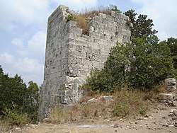 Areimeh Castle | |
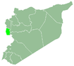
 Areimeh Location in Syria | |
| Coordinates: 34°44′38″N 36°2′50″E | |
| Country | |
| Governorate | Tartus |
| District | Tartus District |
| Subdistrict | Al-Safsafah |
| Population (2004) | |
| • Total | 507 |
| Time zone | UTC+2 (EET) |
| • Summer (DST) | UTC+3 (EEST) |
| City Qrya Pcode | C5331 |
History
The region had an important strategic role, due to its proximity to the Homs Gap, Mount Lebanon, Syrian Coastal Mountain Range and Beqaa Valley. Hence, a Crusader castle (Areimeh Castle) was built there,[2] on Byzantine ruins during the 12th century. It was controlled by Raymond II, Count of Tripoli, then by Bertrand of Toulouse, Alphonse Jourdain's illegitimate son, in 1149, but Raymond recaptured it with the assistance of Muslim rulers. Later on, Raymond ceded the castle to the Knights Templar in the early 1150s. It was taken temporarily by Nur ad-Din Zengi by 1167,[3] damaged after the 1170 earthquake, sacked again by Nur ad-Din in 1171, then recaptured by the Knights Templar in 1177,[4] until they eventually lost it in 1291, although it was temporarily taken by Saladin in 1187.[5]
References
- "General Census of Population 2004". Retrieved 2017-10-20.
- Qalaat Areimeh قلعة العريمة
- Murray 2015, p. 231
- Boas 2006, p. 224
- "Arima". orient-latin.com (in French).
Bibliography
- Boas, Adrian (2006), Archaeology of the Military Orders: A Survey of the Urban Centres, Rural Settlements and Castles of the Military Orders in the Latin East (c.1120-1291), Routledge, ISBN 9781134422845.
- Murray, Alan V. (2015), The Crusades to the Holy Land: The Essential Reference Guide, ABC-CLIO, ISBN 9781610697804.