Ardagh–Johnson Line
The Ardagh–Johnson Line is a proposed boundary of Kashmir abutting Chinese Turkestan and Tibet. It was formally proposed to the British Indian government by Major General John Ardagh, chief of military intelligence in London, in 1897, based on the surveys conducted by William Johnson in 1865.[1]
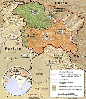
The Ardagh–Johnson Line is one of three boundary lines considered by the British Indian government, the other two being the Macartney–MacDonald Line and a line along the Karakoram range. The British preference among the three choices varied over time based on the perception of their strategic interests in India.[1] The Ardagh–Johnson Line represented the "forward school" that wanted to advance the boundary as forward as possible as a defence against the growing Russian empire.[2] Following the Chinese reluctance to acquiesce to the more conservative Macartney–MacDonald Line, the British eventually reverted to the forward line in the Aksai Chin area, which was then inherited by the independent Republic of India.[3]
Initial survey
W. H. Johnson of the Survey of India was commissioned to survey the Aksai Chin region. Johnson noted that Khotan's border was at Brinjga, in the Kunlun mountains, and the entire the Karakash Valley was within the territory of Kashmir. The boundary of Kashmir that he drew, stretching from Sanju Pass to the eastern edge of Chang Chenmo Valley along the Kunlun mountains, is referred to as the "Johnson Line".[4]
Chinese reception
In 1893, Hung Ta-chen, a senior Chinese official at St. Petersburg,[lower-alpha 1] provided a map which coincided with the Ardagh–Johnson line in broad details. It showed the boundary of Xinjiang up to Raskam. In the east, it was similar to the Ardagh–Johnson line, placing Aksai Chin in Kashmir territory.[5]
Proposal
In 1897 a British military officer, Sir John Ardagh, proposed a boundary line along the crest of the Kun Lun Mountains north of the Yarkand River.[6] At the time Britain was concerned at the danger of Russian expansion as China weakened, and Ardagh argued that his line was more defensible. The Ardagh line was effectively a modification of the Johnson line, and became known as the "Ardagh–Johnson Line".
Aftermath
In 1911 the Xinhai Revolution resulted in power shifts in China, and by the end of World War I, the British officially used the Ardagh–Johnson Line.[7] From 1917 to 1933, the "Postal Atlas of China", published by the Government of China in Peking had shown the boundary in Aksai Chin as per the Ardagh–Johnson line, which runs along the Kunlun mountains.[8][9] The "Peking University Atlas", published in 1925, also put the Aksai Chin in India.[10]
The border of independent India
Upon independence in 1947, the government of India fixed its official boundary in the west, which included the Aksai Chin, in a manner that resembled the Ardagh–Johnson Line. India's basis for defining the border was “chiefly by long usage and custom.”[11]. Unlike the Johnson line, India did not claim the northern areas near Shahidulla and Khotan.
Gallery
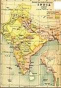 Map of British India, 1837, placed the border along the Kuen Lun range, like the Johnson line.
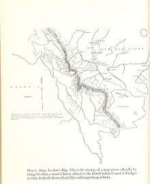 The map given by Hung Ta-chen to the British consul at Kashgar in 1893. The boundary, marked with a thin dot-dashed line, matches the Johnson line for Aksai Chin.[12]
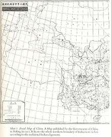 Postal Map of China published by the Government of China in 1917. The boundary in Aksai Chin is as per the Johnson line.
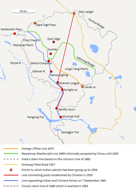 The map shows the Indian claim line in black dashes which is based on the Johnson line.
Notes
- Mehra, An "agreed" frontier 1992, p. 103: "Huang Tachin (also Hung Chun or Hung Tajen) was a Chinese diplomat accredited to Russia as well as Germany, Austria-Hungary and Holland in 1887-90. During these years he rendered into Chinese a series of thirty-five maps, relating for the most part to the Sino-Russian borders."
References
- Hoffmann, India and the China Crisis (1990), p. 12.
- Noorani, India–China Boundary Problem (2010), Chapter 4, "Two Schools on the Boundary".
- Hoffmann, India and the China Crisis (1990), p. 13.
- Fisher, Rose & Huttenback, Himalayan Battleground 1963, p. 116.
- Woodman, Himalayan Frontiers 1970, pp. 73, 78: "Clarke added that a Chinese map drawn by Hung Ta-chen, Minister in St. Petersburg, confirmed the Johnson alignment showing West Aksai Chin as within British (Kashmir) territory."
- Woodman, Dorothy (1969). Himalayan Frontiers. Barrie & Rockcliff. pp. 101 and 360ff.
- Calvin, James Barnard (April 1984). "The China-India Border War". Marine Corps Command and Staff College. Archived from the original on 11 November 2011.
- Woodman, Himalayan Frontiers 1970.
- Verma, Virendra Sahai (2006). "Sino-Indian Border Dispute At Aksai Chin – A Middle Path For Resolution" (PDF). Journal of Development Alternatives and Area Studies. 25 (3): 6–8. ISSN 1651-9728. Retrieved 30 August 2013.
- Fisher, Rose & Huttenback, Himalayan Battleground 1963, p. 101.
- Raghavan, War and Peace in Modern India 2010, p. 235
- Woodman, Himalayan Frontiers 1970, pp. 73, 78.
Bibliography
- Hoffmann, Steven A. (1990), India and the China Crisis, University of California Press, ISBN 978-0-520-06537-6
- Noorani, A.G. (2010), India–China Boundary Problem 1846–1947: History and Diplomacy, Oxford University Press India, doi:10.1093/acprof:oso/9780198070689.001.0001, ISBN 978-0-19-908839-3