Aragvi River
The Aragvi River (Georgian: არაგვი) and its basin are in Georgia on the southern slopes of the Caucasus Mountains. The river is 112 kilometres (70 mi) or 66 kilometres (41 mi)[3] long, and its basin covers an area of 2,724 square kilometres (1,052 sq mi). The ground strata are mostly sandstone, slate, and limestone. The Zhinvali Dam and its 130 MW hydro-electric power station generate much of Georgia's power, and its construction in 1986 formed the Zhinvali Reservoir, upon whose north-western shores rises Ananuri castle with its 17th-century Church of the Assumption.
| Aragvi | |
|---|---|
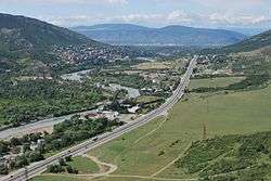 View upstream Aragvi River and along Tbilisi–Senaki–Leselidze highway (taken from around Jvari monastery) | |
| Native name | Georgian: არაგვი |
| Location | |
| Country | Georgia |
| Region | Caucasus |
| Physical characteristics | |
| Source | Caucasus |
| ⁃ location | Gudauri, Mtiuleti, Georgia |
| ⁃ coordinates | 42°20′41″N 44°41′42″E |
| ⁃ elevation | 1,045 m (3,428 ft)[1] |
| Mouth | flows into the Mtkvari |
⁃ location | Mtskheta, Georgia |
⁃ coordinates | 41°50′24″N 44°43′34″E |
⁃ elevation | 445 m (1,460 ft)[2] |
| Length | 112 km (70 mi) or 66 kilometres (41 mi) |
| Basin size | 2,724 km2 (1,052 sq mi) |
Confusion over name and course
Given its etymology (see below; the word simply means "river"), the exact course of the Aragvi River is the source of some confusion. The river has several important tributaries, all called "aragvi":
The Tetri Aragvi ("White Aragvi")[4] flows from Gudauri down to the town of Pasanauri, where it is joined by the Shavi Aragvi ("Black Aragvi"),[5] the main river of Gudamakari to the north-east. Together, these two rivers continue as, simply, "the Aragvi"; from Pasanauri, the Aragvi flows south-east to the Jinvali Reservoir, where it is joined by the Pshav Aragvi[6] (itself fed by the Khevsur Aragvi)[7] before flowing south to merge with the Mtkvari River by Mtskheta, Eastern Georgia's ancient capital just north of Tbilisi.
Etymology
See არაგვი for the origin of the name.
Use and infrastructure
The 102-metre (335 ft) high dam by Jinvali is one of the largest in Georgia. Besides generating up to 130 MW of electricity, the waters of the Aragvi feed down a 36.7-kilometre (22.8 mi) pipe to provide drinking water in Tbilisi and to irrigate fields.
Gallery
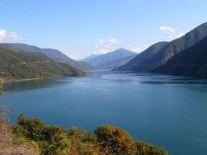 Zhinvali reservoir
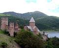 Ananuri castle
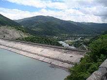 Hydro-electric dam on the Aragvi
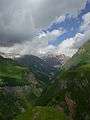 The Source of The Aragvi River to the North of Gudauri
Notes
- Soviet General Staff Maps, 1:50,000 series, sheet K-38-54-W
- Soviet General Staff Maps, 1:50,000 series, sheet M-38-78-A
- Aragvi in the Great Soviet Encyclopedia, 1969–1978 (Russian)
- Georgian: თეთრი არაგვი, tetri aragvi. Source: approx. 42°31'27.13"N, 44°24'2.40"E
- Georgian: შავი არაგვი, shavi aragvi. Source: approx. 42°27'25.18"N, 44°42'40.80"E
- Georgian: ფშავის არაგვი, pshavis aragvi. Source: approx. 42°23'57.01"N, 45°8'42.74"E
- Georgian: ხევსურეთის არაგვი, khevsuretis aragvi. Source: approx. 42°33'45.75"N, 44°57'12.78"E
| Wikimedia Commons has media related to Aragvi River. |