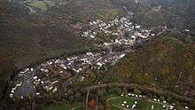
Altenahr
Altenahr is a municipality in the district of Ahrweiler, in Rhineland-Palatinate, Germany. It is the administrative centre for the eponymous collective municipality, to which it belongs. Altenahr is a state-recognised tourist resort and is ranked as a Grundzentrum for state planning purposes.[2]
Altenahr | |
|---|---|
 Coat of arms | |
Location of Altenahr within Ahrweiler district 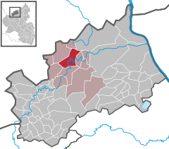  | |
 Altenahr  Altenahr | |
| Coordinates: 50°31′03″N 06°59′19″E | |
| Country | Germany |
| State | Rhineland-Palatinate |
| District | Ahrweiler |
| Municipal assoc. | Altenahr |
| Subdivisions | 4 |
| Government | |
| • Mayor | Rüdiger Fuhrmann (CDU) |
| Area | |
| • Total | 14.84 km2 (5.73 sq mi) |
| Elevation | 170 m (560 ft) |
| Population (2018-12-31)[1] | |
| • Total | 1,870 |
| • Density | 130/km2 (330/sq mi) |
| Time zone | CET/CEST (UTC+1/+2) |
| Postal codes | 53502–53505 |
| Dialling codes | 02643 |
| Vehicle registration | AW |
| Website | www.altenahr.de |
Geography
Location
Altenahr is situated on the river Ahr, on the northeastern edge of the Ahr Hills. part of the Eifel mountains, approximately 10 kilometres west of Bad Neuenahr-Ahrweiler and about 35 kilometres southwest of Bonn.
Administrative organisation
The municipality of Altenahr comprises the following parishes: Altenahr, Altenburg, Kreuzberg and Reimerzhoven.
Neighbouring municipalities
Altenahr borders on the following neighbouring municipalities, listed clockwise from the north: Kalenborn, Grafschaft, Mayschoß, Ahrbrück, Lind and Berg.
Climate
The annual precipitation is 668 mm which is in the middle third of readings collected for Germany as a whole. 34 % of weather stations of the German Meteorological Service record lower values. The driest month is February, the greatest amount of rain falls in July; 1.6 times that of February. However, in general the level of precipitation varies little and is evenly distributed over the year. Only 13 % of weather stations record lower seasonal variations.
History
Altenahr was first mentioned in 893 in the Prüm Urbar.
Incorporations
On 7 June 1969 the hitherto independent municipality of Kreuzberg, with its 560 inhabitants, was incorporated into Altenahr.[3]
Population growth
The growth in Altenahr's population related to the present-day municipal area; the values from 1871 to 1987 are based on censuses:[2][4]
|
|
References
- "Bevölkerungsstand 2018 - Gemeindeebene". Statistisches Landesamt Rheinland-Pfalz (in German). 2019.
- Statistisches Landesamt Rheinland-Pfalz - Regional data
- Statistisches Landesamt Rheinland-Pfalz – Amtliches Gemeindeverzeichnis 2006 Archived 2011-07-18 at the Wayback Machine, pages 168, 177 (pdf; 2.1 MB)
- Statistisches Bundesamt – number of inhabitants in the municipalities on 31 December 2016.
| Authority control |
|
|---|