Alpine, Wyoming
Alpine is a town in Lincoln County, Wyoming, United States. The population was 828 at the 2010 census.
Alpine, Wyoming | |
|---|---|
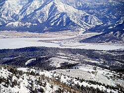 Overview of Alpine | |
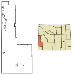 Location of Alpine in Lincoln County, Wyoming. | |
 Alpine, Wyoming Location in the United States | |
| Coordinates: 43°9′40″N 111°1′4″W[1] | |
| Country | United States |
| State | Wyoming |
| County | Lincoln |
| Area | |
| • Total | 0.89 sq mi (2.32 km2) |
| • Land | 0.89 sq mi (2.32 km2) |
| • Water | 0.00 sq mi (0.00 km2) |
| Elevation | 5,633 ft (1,717 m) |
| Population | |
| • Total | 828 |
| • Estimate (2018)[4] | 878 |
| • Density | 982.10/sq mi (379.22/km2) |
| Time zone | UTC-7 (Mountain (MST)) |
| • Summer (DST) | UTC-6 (MDT) |
| ZIP code | 83128 |
| Area code(s) | 307 |
| FIPS code | 56-01695[5] |
| GNIS feature ID | 1597727[6] |
| Website | www |
Geography
Alpine is located at the southern end of the Snake River Canyon where the Snake River enters Palisades Reservoir. The town is also known as Alpine Junction since it marks the point where US Route 89 and US Route 26 turn in opposite directions. The two routes run concurrently through the Snake River Canyon from Jackson, Wyoming. In Alpine, US 89 turns south toward Afton, Wyoming, while US 26 turns north and follows the edge of Palisades Reservoir to Swan Valley, Idaho. Three rivers come together in the vicinity of Alpine: the Snake, the Salt, and the Greys - all three flow into the Palisades Reservoir, with the latter two giving up their waters to the Snake River.
According to the United States Census Bureau, the town has a total area of 0.70 square miles (1.81 km2), all of it land.[7]
Climate
This climatic region is typified by large seasonal temperature differences, with warm to hot (and often humid) summers and cold (sometimes severely cold) winters. According to the Köppen Climate Classification system, Alpine has a humid continental climate, abbreviated "Dfb" on climate maps.[8]
Demographics
| Historical population | |||
|---|---|---|---|
| Census | Pop. | %± | |
| 1990 | 200 | — | |
| 2000 | 550 | 175.0% | |
| 2010 | 828 | 50.5% | |
| Est. 2018 | 878 | [4] | 6.0% |
| U.S. Decennial Census[9] | |||
2010 census
As of the census[3] of 2010, there were 828 people, 346 households, and 221 families living in the town. The population density was 1,182.9 inhabitants per square mile (456.7/km2). There were 449 housing units at an average density of 641.4 per square mile (247.6/km2). The racial makeup of the town was 95.2% White, 0.4% African American, 0.2% Native American, 0.5% Asian, 2.4% from other races, and 1.3% from two or more races. Hispanic or Latino of any race were 5.6% of the population.
There were 346 households, of which 29.5% had children under the age of 18 living with them, 53.8% were married couples living together, 5.8% had a female householder with no husband present, 4.3% had a male householder with no wife present, and 36.1% were non-families. 20.2% of all households were made up of individuals, and 1.8% had someone living alone who was 65 years of age or older. The average household size was 2.39 and the average family size was 2.83.
The median age in the town was 36.6 years. 21% of residents were under the age of 18; 8.1% were between the ages of 18 and 24; 37.8% were from 25 to 44; 27.3% were from 45 to 64; and 5.8% were 65 years of age or older. The gender makeup of the town was 53.3% male and 46.7% female.
2000 census
As of the census[5] of 2000, there were 550 people, 217 households, and 146 families living in the town. The population density was 787.9 people per square mile (303.4/km2). There were 274 housing units at an average density of 392.5 per square mile (151.1/km2). The racial makeup of the town was 96.73% White, 0.73% Native American, 0.73% Asian, 0.18% Pacific Islander, and 1.64% from two or more races. Hispanic or Latino of any race were 1.09% of the population.
There were 217 households, out of which 27.6% had children under the age of 18 living with them, 61.8% were married couples living together, 5.1% had a female householder with no husband present, and 32.7% were non-families. 18.4% of all households were made up of individuals, and 3.2% had someone living alone who was 65 years of age or older. The average household size was 2.53 and the average family size was 2.99.
In the town, the population was spread out, with 23.8% under the age of 18, 6.5% from 18 to 24, 36.7% from 25 to 44, 25.3% from 45 to 64, and 7.6% who were 65 years of age or older. The median age was 36 years. For every 100 females, there were 107.5 males. For every 100 females age 18 and over, there were 97.6 males.
The median income for a household in the town was $45,313, and the median income for a family was $47,813. Males had a median income of $35,313 versus $23,036 for females. The per capita income for the town was $21,223. About 3.4% of families and 5.1% of the population were below the poverty line, including 4.1% of those under age 18 and none of those age 65 or over.
Education
Public education in the town of Alpine is provided by Lincoln County School District #2.
Alpine has a public library, a branch of the Lincoln County Library System.[10]
See also
References
- "US Gazetteer files: 2010, 2000, and 1990". United States Census Bureau. 2011-02-12. Retrieved 2011-04-23.
- "2018 U.S. Gazetteer Files". United States Census Bureau. Retrieved Feb 16, 2020.
- "U.S. Census website". United States Census Bureau. Retrieved 2012-12-14.
- "Population and Housing Unit Estimates". Retrieved June 4, 2019.
- "U.S. Census website". United States Census Bureau. Retrieved 2008-01-31.
- "US Board on Geographic Names". United States Geological Survey. 2007-10-25. Retrieved 2008-01-31.
- "US Gazetteer files 2010". United States Census Bureau. Archived from the original on 2012-01-25. Retrieved 2012-12-14.
- Climate Summary for Alpine, Wyoming
- "Census of Population and Housing". Census.gov. Retrieved June 4, 2015.
- "Wyoming Public Libraries". PublicLibraries.com. Retrieved 13 June 2019.
External links
| Wikivoyage has a travel guide for Alpine (Wyoming). |
Municipalities and communities of Lincoln County, Wyoming, United States | ||
|---|---|---|
| City | 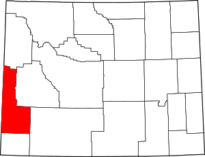 | |
| Towns | ||
| CDPs | ||
| Unincorporated communities | ||
| Footnotes | ‡This populated place also extends into Idaho | |