Alabama State Route 58
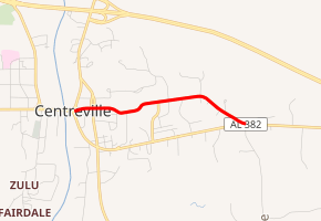
State Route 58 (SR 58) was a 1.648-mile-long (2.652 km) state highway in Centreville in Bibb County. The western terminus of the highway was at an intersection with US 82/SR 25/SR 219. The eastern terminus of the highway was at a second intersection with US 82. SR 58 traveled through the historic business district of Centreville.
| ||||
|---|---|---|---|---|
| ||||
| Route information | ||||
| Maintained by ALDOT | ||||
| Length | 1.648 mi[1] (2.652 km) | |||
| Existed | ?–2015 | |||
| Major junctions | ||||
| West end | ||||
| East end | ||||
| Highway system | ||||
| ||||

Route description
SR 58 began at an intersection with former US 82/SR 6/SR 25/SR 219 (now SR 382) in Centreville, heading east on two-lane undivided Walnut Street. The highway headed into the historic business district of the town, intersecting former SR 209 at the town square. Farther east, the highway headed into wooded residential areas. SR 58 curved to the southeast and reaches its eastern terminus at an intersection with US 82/SR 6.[1][2][3]
History
State Route 58 was decommissioned in 2015. After that, all of the mileage, along with the mileage of State Route 209, was transferred to SR 382.
Major intersections
The entire route is in Centreville, Bibb County.
| mi[1] | km | Destinations | Notes | ||
|---|---|---|---|---|---|
| 0.000 | 0.000 | Western terminus | |||
| 0.188 | 0.303 | Southern terminus of SR 209 | |||
| 1.648 | 2.652 | Eastern terminus | |||
| 1.000 mi = 1.609 km; 1.000 km = 0.621 mi | |||||
See also


References
- Milepost Map (Map). Alabama Department of Transportation. Archived from the original (PDF) on July 27, 2011. Retrieved March 29, 2011.
- General Highway Map (Map). Alabama Department of Transportation. Archived from the original (PDF) on July 27, 2011. Retrieved March 29, 2011.
- Google (March 30, 2011). "overview of Alabama State Route 58" (Map). Google Maps. Google. Retrieved March 30, 2011.