Akune, Kagoshima
Akune (阿久根市, Akune-shi) is a city located in Kagoshima Prefecture, Japan. The city was founded on April 1, 1952.
Akune 阿久根市 | |
|---|---|
 Flag  Emblem | |
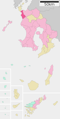
 Location of Akune in Kagoshima Prefecture | |
 Akune Location in Japan | |
| Coordinates: 32°1′N 130°13′E | |
| Country | Japan |
| Region | Kyushu |
| Prefecture | Kagoshima Prefecture |
| Government | |
| • Mayor | Yoshimasa Nishihira (since January 2011) |
| Area | |
| • Total | 134.30 km2 (51.85 sq mi) |
| Population (April 2008) | |
| • Total | 23,887 |
| • Density | 178/km2 (460/sq mi) |
| Symbols | |
| • Tree | Pomelo |
| • Flower | Tsuwabuki (Asteraceae farfugium japonicum) |
| Time zone | UTC+9 (JST) |
| City hall address | 200 Tsurumichō, Akune-shi, Kagoshima-ken 899-1696 |
| Website | www |
As of 2008, the city has an estimated population of 23,887 and a population density of 178 persons per km². The total area is 134.30 km².
Climate
Akune has a humid subtropical climate (Köppen climate classification Cfa) with hot summers and mild winters. Precipitation is significant throughout the year, and is heavier in summer, especially the months of June and July.
| Climate data for Akune, Kagoshima | |||||||||||||
|---|---|---|---|---|---|---|---|---|---|---|---|---|---|
| Month | Jan | Feb | Mar | Apr | May | Jun | Jul | Aug | Sep | Oct | Nov | Dec | Year |
| Record high °C (°F) | 22.8 (73.0) |
24.0 (75.2) |
25.6 (78.1) |
27.8 (82.0) |
30.3 (86.5) |
33.6 (92.5) |
36.6 (97.9) |
37.1 (98.8) |
34.9 (94.8) |
32.7 (90.9) |
28.0 (82.4) |
23.7 (74.7) |
37.1 (98.8) |
| Mean maximum °C (°F) | 18.1 (64.6) |
19.3 (66.7) |
22.1 (71.8) |
25.0 (77.0) |
27.6 (81.7) |
30.4 (86.7) |
33.2 (91.8) |
34.1 (93.4) |
32.2 (90.0) |
28.4 (83.1) |
24.3 (75.7) |
20.0 (68.0) |
34.3 (93.7) |
| Average high °C (°F) | 10.4 (50.7) |
11.3 (52.3) |
14.5 (58.1) |
19.4 (66.9) |
22.8 (73.0) |
25.4 (77.7) |
29.2 (84.6) |
30.4 (86.7) |
27.7 (81.9) |
23.2 (73.8) |
18.2 (64.8) |
13.0 (55.4) |
20.5 (68.8) |
| Daily mean °C (°F) | 7.0 (44.6) |
7.7 (45.9) |
10.6 (51.1) |
15.4 (59.7) |
18.9 (66.0) |
22.1 (71.8) |
26.1 (79.0) |
26.7 (80.1) |
23.9 (75.0) |
19.1 (66.4) |
14.2 (57.6) |
9.3 (48.7) |
16.7 (62.2) |
| Average low °C (°F) | 3.7 (38.7) |
4.3 (39.7) |
6.8 (44.2) |
11.6 (52.9) |
15.4 (59.7) |
19.2 (66.6) |
23.4 (74.1) |
23.7 (74.7) |
20.8 (69.4) |
15.5 (59.9) |
10.6 (51.1) |
6.0 (42.8) |
13.4 (56.2) |
| Mean minimum °C (°F) | −0.2 (31.6) |
−0.1 (31.8) |
1.9 (35.4) |
5.5 (41.9) |
11.1 (52.0) |
15.5 (59.9) |
20.4 (68.7) |
21.4 (70.5) |
16.8 (62.2) |
10.8 (51.4) |
5.5 (41.9) |
1.2 (34.2) |
−1.2 (29.8) |
| Record low °C (°F) | −4.2 (24.4) |
−4.6 (23.7) |
−1.6 (29.1) |
0.9 (33.6) |
8.2 (46.8) |
12.4 (54.3) |
17.1 (62.8) |
18.7 (65.7) |
12.0 (53.6) |
5.9 (42.6) |
1.5 (34.7) |
−2.3 (27.9) |
−4.6 (23.7) |
| Average precipitation mm (inches) | 92.0 (3.62) |
93.6 (3.69) |
134.4 (5.29) |
177.4 (6.98) |
204.1 (8.04) |
366.5 (14.43) |
338.3 (13.32) |
201.5 (7.93) |
198.3 (7.81) |
101.7 (4.00) |
90.5 (3.56) |
76.4 (3.01) |
2,074.7 (81.68) |
| Average snowfall cm (inches) | 5 (2.0) |
4 (1.6) |
0 (0) |
0 (0) |
0 (0) |
0 (0) |
0 (0) |
0 (0) |
0 (0) |
0 (0) |
0 (0) |
2 (0.8) |
11 (4.4) |
| Average relative humidity (%) | 69 | 70 | 70 | 75 | 78 | 84 | 85 | 82 | 80 | 73 | 70 | 69 | 75 |
| Mean monthly sunshine hours | 108.7 | 110.8 | 155.7 | 162.1 | 176.6 | 143.2 | 204.9 | 228.5 | 183.3 | 189.9 | 148.6 | 121.5 | 1,933.8 |
| Source: NOAA (1961-1990)[1] | |||||||||||||
References
- "Akune Climate Normals 1961-1990". National Oceanic and Atmospheric Administration. Retrieved January 6, 2013.
External links
| Wikimedia Commons has media related to Akune, Kagoshima. |
This article is issued from Wikipedia. The text is licensed under Creative Commons - Attribution - Sharealike. Additional terms may apply for the media files.