Airport, Roanoke, Virginia
Airport is a Roanoke, Virginia neighborhood located in north, central Roanoke surrounded roughly by Virginia State Route 118 to the south and by Interstate 581 to the west, centered on the Roanoke Regional Airport. It borders the neighborhoods of Miller Court/Arrowood on the west, Roundhill on the south and Roanoke County on the north and east.[1]
Airport | |
|---|---|
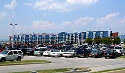 Roanoke Regional Airport terminal building | |
 Airport  Airport | |
| Coordinates: 37°19′18.7″N 79°58′13″W | |
| Country | |
| State | |
| City | Roanoke |
| Time zone | UTC-5 (EST) |
| • Summer (DST) | UTC-4 (EDT) |
| ZIP Codes | 24012 |
| Area code(s) | 540 |
History
Annexed from Roanoke County in 1976,[2] most development within the Airport neighborhood has been commercial in nature beginning with the opening of Crossroads Mall in 1961.[3] Outside of the Roanoke Regional Airport property, the area remains primarily commercial and is also the location of the Advance Auto Parts corporate headquarters.
References
- "Explore Roanoke Neighborhood Map: Airport". City of Roanoke Department of Neighborhoods. Archived from the original on 2012-12-08. Retrieved 2008-04-29.
- Kagey, Deedie (1988). "Annexations Continue". When Past Is Prologue: A History of Roanoke County (1st ed.). Roanoke, VA: Roanoke County Sesquicentennial Committee. p. 547.
- "Williamson Road Area Plan: Development History" (PDF). City of Roanoke Planning Division. Archived from the original (PDF) on 2011-07-21. Retrieved 2008-04-06.
External links
Williamson Road Area Plan which includes the Airport neighborhood