Agia Varvara, Heraklion
Agia Varvara (Greek: Αγία Βαρβάρα) is a village and a former municipality in the Heraklion regional unit, Crete, Greece. Since the 2011 local government reform it is part of the municipality Gortyn, of which it is a municipal unit.[2] The municipal unit has an area of 99.038 km2 (38.239 sq mi).[3] Population 4,587 (2011). The village lies at an altitude of about 580 meters and has 2,043 inhabitants.
Agia Varvara Αγία Βαρβάρα | |
|---|---|
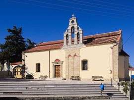 The church of Agia Varvara | |
 Agia Varvara Location within the regional unit 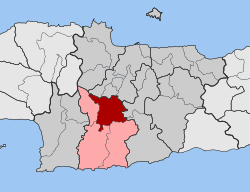 | |
| Coordinates: 35°08′N 25°00′E | |
| Country | Greece |
| Administrative region | Crete |
| Regional unit | Heraklion |
| Municipality | Gortyn |
| • Municipal unit | 99.0 km2 (38.2 sq mi) |
| Elevation | 580 m (1,900 ft) |
| Population (2011)[1] | |
| • Municipal unit | 4,587 |
| • Municipal unit density | 46/km2 (120/sq mi) |
| Community | |
| • Population | 2,043 (2011) |
| Time zone | UTC+2 (EET) |
| • Summer (DST) | UTC+3 (EEST) |
Agia Varvara lies on the busy north–south road from Heraklion on the north coast of the island towards the centre.
References
- "Απογραφή Πληθυσμού - Κατοικιών 2011. ΜΟΝΙΜΟΣ Πληθυσμός" (in Greek). Hellenic Statistical Authority.
- Kallikratis law Greece Ministry of Interior (in Greek)
- "Population & housing census 2001 (incl. area and average elevation)" (PDF) (in Greek). National Statistical Service of Greece. Archived from the original (PDF) on 2015-09-21.
This article is issued from Wikipedia. The text is licensed under Creative Commons - Attribution - Sharealike. Additional terms may apply for the media files.