Afghanistan–Uzbekistan border
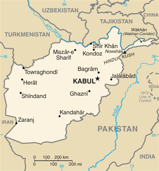
The Afghanistan-Uzbekistan border is 144 km (89 mi) in length and runs from the tripoint with Turkmenistan to the tripoint with Tajikistan along the Amu Darya river.[1] It is by far the shortest of Uzbekistan's external borders.
Description
The entire border follows the thalweg of the Amu Darya river, from the Turkmen tripoint in the west to the Tajik tripoint in the east. The border is paralleled on the Uzbek side by a road and railway line, and there is a major crossing point to the east of the Uzbek town of Termez.[2]
Uzbekistan has built a barrier along the border, consisting of a barbed wire fence and a second, taller, 380-volt electrified barbed-wire fence, land mines and a patrol of heavily armed Uzbek soldiers.[3][4]
History
The border was inherited from the old Soviet Union-Afghan border which largely took its current shape during the 19th century Anglo-Russian rivalry in Central Asia known as the Great Game. With the Russian Empire having conquered the Khanate of Khiva and the Emirate of Bukhara, and with the British Empire controlling the British Raj, the two powers agreed to leave Afghanistan as an independent buffer state between them.[2]
In 1873 Britain and Russia agreed on a rough formulation of the border, with the Amu Darya declared to be the border going east from the vicinity of the village of Khwaja Salar to Lake Zorku, with the Wakhan Corridor to remain in Afghanistan. The western section of the border (i.e. the bulk of the modern Afghan-Turkmen boundary) was to be determined at a later date by a boundary commission.[2]
Tensions mounted as the Russians expanded further into what is now Turkmenistan in the early 1880s, reaching a crisis with the Panjdeh incident (near Sandykachi in what is now Turkmenistan), an area claimed by Afghanistan. Discussions calmed the situation and a joint Anglo-Russian boundary commission demarcated the boundary as it is today over the period 1885-88. As the village of Khwaja Salar could no longer be identified it was agreed that the boundary should meet the Amu Darya in the vicinity of Khamiab, Afghanistan.[2]
The eastern-most section of the border (now forming part of the Afghan-Tajik boundary) was not finally delimited until 1893-95, with the Afghans agreeing to waive any claims to lands north the Amu Darya. This agreement also stipulated the position of the land border in section east of Lake Zorkul up to China, with a series of boundary pillars subsequently erected.[2]
In 1921 a Soviet-Afghan treaty was signed whereby Russia agreed “to hand over to Afghanistan the frontier districts which belonged to the latter in the last century, observing the principles of justice and self-determination of the population inhabiting the same." However this treaty was never implemented, and was explicitly annulled by the Frontier Agreement of 1946, which kept the boundary as it was, with riverine islands to be subsequently allocated by a joint commission.[2]
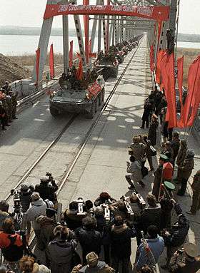
In 1979 Soviet troops of the 40th Army crossed the border at Termez via a series of pontoons as part of the Soviet Invasion of Afghanistan, en route to Mazar-i-Sharif and Kabul.[5] They later constructed the Friendship Bridge, which officially opened in 1982, however its strategic importance led to it being a target of the Mujahideen insurgency.[6] The Soviet army left Afghanistan via the bridge in 1989.
The bridge was closed from 1997-2001 due to Uzbek fears over Taliban insurgency, before re-opening to allow aid in following their fall in 2001.[7] As of 2018 it remains the only fixed crossing between Uzbekistan and Afghanistan.
Border crossings
- Hairatan (AFG)-Termez (UZB) (rail and road, see Afghanistan–Uzbekistan Friendship Bridge)[8][9]
See also
- Afghanistan–Uzbekistan relations
References
- CIA World Factbook - Afghanistan, 8 September 2018
- International Boundary Study No. 26 - Afghanistan-USSR Boundary (PDF), 15 September 1983, retrieved 8 September 2018
- McElroy, Damien (November 11, 2001). "Tashkent urged to allow UN aid across bridge". The Daily Telegraph. Archived from the original on September 7, 2012. Retrieved 2007-06-07.
- Bivens, Matt (November 16, 2001). "The Afghan Humanitarian Crisis". The Nation. Retrieved 2007-06-07.
- BBC Timeline: Soviet War in Afghanistan, retrieved 8 September 2018
- Hairatan and the Friendship Bridge, retrieved 8 September 2018
- CNN - Aid flows as key Afghan border bridge re-opens, 9 December 2001, retrieved 8 September 2018
- Caravanistan - Uzbekistan-Afghanistan border crossings, retrieved 8 September 2018
- Naima Suleyman, Urakbai Ketbenbaev (October 2, 2001). "Uzbek Forces on War Footing". Institute for War & Peace Reporting. Archived from the original on September 26, 2007. Retrieved 2007-06-07.