2011 Smithville, Mississippi tornado
On Wednesday, April 27, 2011, an extremely violent EF5 wedge tornado, with estimated winds of up to 205 mph (330 km/h), struck the town of Smithville, Mississippi at 3:47 p.m. CDT (2047 UTC) on April 27, resulting in catastrophic damage and numerous fatalities.[1]
| EF5 tornado | |
|---|---|
Part of the 2011 Super Outbreak | |
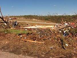
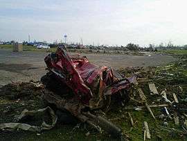 The remains of an SUV that was thrown half a mile into the top of the water tower seen in the background before bouncing off of it, traveling another 1/4 mile in the air, impacting the ground and eventually coming to rest in the parking lot of the E.E. Pickle Funeral Home on the opposite side of town. | |
| Formed | April 27, 2011, 3:40 p.m. CDT (UTC–05:00) |
| Duration | 43 minutes |
| Dissipated | April 27, 2011, 4:23 p.m. CDT (UTC–05:00) |
| Max. rating1 | EF5 tornado |
| Highest winds |
|
| Casualties | 23 fatalities, 137 injuries |
| 1Most severe tornado damage; see Enhanced Fujita scale | |
Meteorological synopsis
The environmental conditions leading up to the April 2011 Super Outbreak were among the "most conducive to violent tornadoes ever documented".[2] On April 25, a vigorous upper-level shortwave trough that moved into the Southern Plains states.[3] Ample instability, low-level moisture, and wind shear fueled a significant tornado outbreak from Texas to Tennessee; at least 64 tornadoes touched down on this day.[2] An area of low pressure consolidated over Texas on April 26 and traveled east while the aforementioned shortwave trough traversed the Mississippi River and Ohio River valleys.[4] Another 50 tornadoes touched down on this day.[2] The multi-day outbreak culminated on April 27 with the most violent day of tornadic activity since the 1974 Super Outbreak. Multiple episodes of tornadic activity ensued with two waves of mesoscale convective systems in the morning hours followed by a widespread outbreak of supercells from Mississippi to North Carolina during the afternoon into the evening.[2]
Activity on April 27 was precipitated by a 995 mbar (hPa; 29.39 inHg) surface low situated over Kentucky and a deep, negatively tilted (aligned northwest to southeast) trough over Arkansas and Louisiana. A strong southwesterly surface jet intersected these systems at a 60° angle, an ageostrophic flow that led to storm-relative helicity values in excess of 500 m2s−2—indicative of extreme wind shear and a very high potential for rotating updrafts within supercells. Ample moisture from the Gulf of Mexico was brought north across the Deep South, leading to daytime high temperatures of 77 to 81 °F (25 to 27 °C) and dewpoints of 66 to 72 °F (19 to 22 °C). Furthermore, convective available potential energy (CAPE) values reached 2,500–3,000 J/kg−1.[2]
Tornado summary
The tornado began 3 miles (4.8 km) west-southwest of Smithville along the Tennessee–Tombigbee Waterway near the Glover Wilkins Lock at 3:42 p.m. CDT (2042 UTC), snapping numerous trees near the Smithville Recreation Area. The tornado then rapidly intensified as it approached town, reaching EF5 intensity. As the storm crossed Davis Road South, the ground was deeply scoured in a nearby field.[5] The tornado swept away dozens of homes and structures as it moved northeast, following Highway 25. A semi-truck was thrown a considerable distance and destroyed in this area. One brick residence was swept away here as well, and part of its concrete foundation slab was pulled up and slightly dislodged.[1][5]
The tornado then entered Smithville at maximum intensity and first struck residential areas in this place, completely sweeping away dozens of well-built brick homes with anchor bolts, and completely debarking several hardwood trees. All furniture, appliances, and plumbing from homes in the tornado's direct path of were either shredded or missing, and a few homes had floor tiles scoured from their foundations. Shrubbery along the perimeters of some homes was shredded and/or stripped as well. An SUV was thrown a 1⁄2-mile (0.80 km) into the top of the Smithville water tower, then bounced off of it, and was hurled an additional 1⁄4-mile (400 m) before impacting the ground and eventually coming to rest on the opposite side of the city, where it was later found crushed into a tiny ball. The city hall, the post office, four churches, several businesses, the water system, and the police station were all destroyed in the process. Tar and chip pavement was torn from a road in town and rolled into piles, ground scouring was noted in several areas, and a 1965 Chevrolet pickup truck was thrown from one residence and never found.[1][6][7] The local medical clinic was destroyed as well, with supplies being scattered around the city.[8] The large brick E.E. Pickle Funeral Home was reduced to a bare slab as the tornado exited at the northeast side of the city, with the debris scattered and wind-rowed into an adjacent wooded area. Nearby granite tombstones from a cemetery were blown over in the opposite direction of the tornado's passage. Overall, the tornado destroyed 117 structures in Smithville and damaged 50 others, killing 16 people.[6] The tornado weakened as it continued through rural areas northeast of town and moved into Itawamba County, where it uprooted numerous trees and power lines and caused roof damage to a house before exiting the county.[5][9]
The tornado then continued across the Alabama state line into Marion County, where it caused EF1 damage to outbuildings and mobile homes near Bexar. Continuing northeast, the tornado re-intensified as it struck the rural community of Shottsville at high-end EF3 intensity, where homes and mobile homes were destroyed, hundreds of trees were snapped and debarked, and seven more people were killed. The tornado produced additional high-end EF3 damage as it continued north of Hamilton, where several mobile homes and frame homes were destroyed, including one frame home at the bottom of a ravine that was swept clean from its foundation (though lack of road access prevented close inspection of the home's construction, precluding a potential higher rating at that location).[10] Several additional homes were damaged and a chicken house was destroyed as the tornado approached Franklin County. The tornado then crossed the county line and weakened to EF2 strength, where it snapped and uprooted numerous large trees, damaged or destroyed several chicken houses, totaled a car, destroyed a mobile home, tore much of the roof off of a two-story house, and caused significant roof damage to several other homes before dissipating near the town of Hodges at 4:23 p.m. CDT (2123 UTC). The damage path was 37.3 miles (60.0 km) long and 3⁄4 mile (1.2 km) wide at its widest point, and it killed a total of 23 people along its path. 137 other people were injured.[10][11]
References
- "Smithville, MS EF-5 Tornado". National Weather Service in Memphis, Tennessee. National Oceanic and Atmospheric Administration. May 30, 2011. Retrieved July 15, 2013.
- Kevin R. Knupp; et al. (July 2014). "Meteorological Overview of the Devastating 27 April 2011 Tornado Outbreak". Bulletin of the American Meteorological Society. American Meteorological Society. 95 (7): 1, 041–1, 062. Bibcode:2014BAMS...95.1041K. doi:10.1175/BAMS-D-11-00229.1.
- Ryan E. Jewell (April 25, 2011). Apr 25, 2011 0600 UTC Day 1 Convective Outlook (Report). Norman, Oklahoma: Storm Prediction Center. Retrieved May 15, 2016.
- Ryan E. Jewell (April 26, 2011). Apr 26, 2011 0600 UTC Day 1 Convective Outlook (Report). Norman, Oklahoma: Storm Prediction Center. Retrieved May 15, 2016.
- "April 2011 Tornado Response Imagery". National Geodetic Survey. National Oceanic and Atmospheric Administration. 2011. Archived from the original on 2013-12-29. Retrieved June 20, 2014.
- National Climatic Data Center (2011). "NCDC Storm Events Database". National Oceanic and Atmospheric Administration. Retrieved June 13, 2014.
- Richard Okulski; Brad Panovich (October 17, 2011). Smithville, MS Tornado presentation. National Oceanic and Atmospheric Administration. YouTube. Retrieved June 20, 2014.
- Kristina Goetz (October 23, 2011). "Deadly tornado destroyed town, not spirit, of tiny Smithville, Miss". The Commercial Appeal. Retrieved June 20, 2014.
- National Climatic Data Center (2011). "NCDC Storm Events Database". National Oceanic and Atmospheric Administration. Retrieved June 20, 2014.
- "Franklin County Alabama (Hodges Area) EF-2". National Weather Service in Huntsville, Alabama. National Oceanic and Atmospheric Administration. June 5, 2012. Retrieved July 20, 2014.
- "Shottsville (Marion County) EF-3 Tornado April 27, 2011". National Weather Service in Birmingham, Alabama. National Oceanic and Atmospheric Administration. August 23, 2011. Retrieved July 15, 2013.
External links
- http://www.srh.noaa.gov/meg/?n=apr2011toroutbreaksmithville
- https://web.archive.org/web/20160520115254/http://ngs.woc.noaa.gov/storms/apr11_tornado/
- http://www.ncdc.noaa.gov/stormevents/eventdetails.jsp?id=303562
- https://www.youtube.com/watch?v=fmI_2iYuchc
- http://www.commercialappeal.com/news/2011/oct/23/deadly-tornado-smithville-mississippi
- http://www.ncdc.noaa.gov/stormevents/eventdetails.jsp?id=303563
- http://www.srh.noaa.gov/hun/?n=4272011_franklin_county_hodges
- http://www.srh.noaa.gov/bmx/?n=event_04272011shotsville