145th Street Bridge
The 145th Street Bridge, located in New York City, is a four-lane swing bridge that crosses the Harlem River, connecting 145th Street and Lenox Avenue in Manhattan with East 149th Street and River Avenue in the Bronx. It once carried northbound New York State Route 22 and New York State Route 100. Additionally, this bridge, for its proximity to the eponymous avenue, was once named the "Lenox Avenue Bridge," an original name that has fallen into disuse. The bridge is operated and maintained by the New York City Department of Transportation.
145th Street Bridge | |
|---|---|
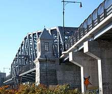 View from the Bronx | |
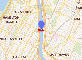
| Coordinates | 40.819461°N 73.933053°W |
| Carries | Four lanes of 145th Street |
| Crosses | Harlem River |
| Locale | Manhattan and the Bronx, New York City |
| Owner | City of New York |
| Maintained by | NYCDOT[1] |
| Preceded by | Macombs Dam Bridge |
| Followed by | Madison Avenue Bridge |
| Characteristics | |
| Design | Swing bridge[1] |
| Total length | 1,602 feet (488.29 m)[1] |
| Longest span | 300 feet (91.44 m)[1] |
| History | |
| Construction cost | $85 million[1] |
| Opened | August 4, 1905[1] |
| Rebuilt | November 2006[1] |
| Statistics | |
| Daily traffic | 29,315 (2016)[2] |
| |

Construction on the original 145th Street Bridge began on April 19, 1901, and the $2.75 million bridge was opened to traffic on August 24, 1905. The designer was Alfred Pancoast Boller.
A new swing span for the bridge was assembled in the Port of Coeymans in Coeymans, New York, in southern Albany County. The span was replaced in early November 2006.[3]
The 145th Street Bridge carries the Bx19 bus route operated by MTA New York City Transit.[4][5]
References
- Michael R. Bloomberg, City of New York (January 23, 2004). "New York City's Harlem River Bridges: The Reauthorization of the Transportation Equity Act for the 21st Century" (PDF). Retrieved December 2, 2017.
- "New York City Bridge Traffic Volumes" (PDF). New York City Department of Transportation. 2016. p. 9. Retrieved March 16, 2018.
- "New 145th Street Bridge Arrives in the City Via Barge". The New York Sun. November 1, 2006. Retrieved January 5, 2020.
- "Manhattan Bus Map" (PDF). Metropolitan Transportation Authority. December 2017. Retrieved April 24, 2018.
- "Bronx Bus Map" (PDF). Metropolitan Transportation Authority. September 2017. Retrieved April 24, 2018.
External links
| Wikimedia Commons has media related to 145th Street Bridge (New York City). |
Crossings of the Harlem River | ||||
|---|---|---|---|---|
| ||||