Černá Voda
Černá Voda (German: Schwarzwasser, both meaning "black water") is a village and municipality (obec) in Jeseník District in the Olomouc Region of the Czech Republic.
Černá Voda | |
|---|---|
Municipality | |
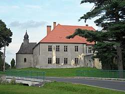 Chateau in the village | |
 Flag  Coat of arms | |
 Černá Voda | |
| Coordinates: 50°18′30″N 17°9′21″E | |
| Country | |
| Region | Olomouc |
| District | Jeseník |
| Area | |
| • Total | 9.96 km2 (3.85 sq mi) |
| Elevation | 340 m (1,120 ft) |
| Population (2006) | |
| • Total | 629 |
| • Density | 63/km2 (160/sq mi) |
| Postal code | 790 54 |
| Website | http://www.obeccernavoda.cz/ |
The municipality covers an area of 9.96 square kilometres (3.85 sq mi), and has a population of 629 (as at 3 July 2006).
Černá Voda lies approximately 9 kilometres (6 mi) north of Jeseník, 80 km (50 mi) north of Olomouc, and 197 km (122 mi) east of Prague.
This article is issued from Wikipedia. The text is licensed under Creative Commons - Attribution - Sharealike. Additional terms may apply for the media files.