Ørsta (village)
Ørsta is the administrative centre of Ørsta Municipality in Møre og Romsdal county, Norway. The village is located at the innermost part of the Ørstafjorden, surrounded by the Sunnmørsalpene mountains. The village of Volda is located about 10 kilometres (6.2 mi) southwest of Ørsta.[3]
Ørsta | |
|---|---|
Town | |
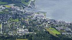 View of the village | |
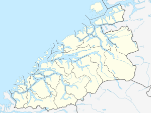 Ørsta Location in Møre og Romsdal  Ørsta Ørsta (Norway) | |
| Coordinates: 62.1998°N 6.1290°E | |
| Country | Norway |
| Region | Western Norway |
| County | Møre og Romsdal |
| District | Sunnmøre |
| Municipality | Ørsta Municipality |
| Area | |
| • Total | 5.38 km2 (2.08 sq mi) |
| Elevation | 6 m (20 ft) |
| Population (2018)[1] | |
| • Total | 7,308 |
| • Density | 1,358/km2 (3,520/sq mi) |
| Time zone | UTC+01:00 (CET) |
| • Summer (DST) | UTC+02:00 (CEST) |
| Post Code | 6150 Ørsta |
The 5.38-square-kilometre (1,330-acre) village has a population (2018) of 7,308 and a population density of 1,358 inhabitants per square kilometre (3,520/sq mi). This makes it the fourth largest urban area in all of Møre og Romsdal county.[1]
Ørsta is the seat of the municipal government and it is also the commercial centre of the municipality. There is a shopping center, industry, and Ørsta-Volda Airport (on the southwest side of the village area). Ørsta Church is also located in central part of Ørsta. A videregående skole (regional high school) and the Møre Folkehøgskule are both located in Ørsta.
References
- Statistisk sentralbyrå (1 January 2018). "Urban settlements. Population and area, by municipality".
- "Ørsta (Møre og Romsdal)". yr.no. Retrieved 2019-09-19.
- Store norske leksikon. "Ørsta – tettsted" (in Norwegian). Retrieved 2013-08-09.