Zwingenberg (Baden)
| Zwingenberg | ||
|---|---|---|
| ||
 Zwingenberg Location of Zwingenberg within Neckar-Odenwald-Kreis district 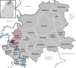 | ||
| Coordinates: 49°24′55″N 9°2′35″E / 49.41528°N 9.04306°ECoordinates: 49°24′55″N 9°2′35″E / 49.41528°N 9.04306°E | ||
| Country | Germany | |
| State | Baden-Württemberg | |
| Admin. region | Karlsruhe | |
| District | Neckar-Odenwald-Kreis | |
| Government | ||
| • Mayor | Norman Link (CDU) | |
| Area | ||
| • Total | 4.7 km2 (1.8 sq mi) | |
| Elevation | 148 m (486 ft) | |
| Population (2017-12-31)[1] | ||
| • Total | 704 | |
| • Density | 150/km2 (390/sq mi) | |
| Time zone | CET/CEST (UTC+1/+2) | |
| Postal codes | 69439 | |
| Dialling codes | 06263 | |
| Vehicle registration | MOS, BCH | |
| Website | www.zwingenberg-neckar.de | |
.svg.png)
Zwingenberg am Neckar is a village in the district of Neckar-Odenwald-Kreis, in Baden-Württemberg, Germany.
Zwingenberg Castle, a former castle, now a schloss, stands on a hillside above the River Neckar and the village.
Towns and municipalities in Neckar-Odenwald (district) | ||
|---|---|---|
References
- ↑ "Bevölkerung nach Nationalität und Geschlecht am 31. Dezember 2017". Statistisches Landesamt Baden-Württemberg (in German). 2018.
This article is issued from
Wikipedia.
The text is licensed under Creative Commons - Attribution - Sharealike.
Additional terms may apply for the media files.