Zielonka
| Zielonka | ||
|---|---|---|
 Our Lady of Częstochowa Church | ||
| ||
 Zielonka | ||
| Coordinates: 52°18′3″N 21°9′31″E / 52.30083°N 21.15861°E | ||
| Country |
| |
| Voivodeship | Masovian | |
| County | Wołomin | |
| Gmina | Zielonka (urban gmina) | |
| Town rights | 1960 | |
| Government | ||
| • Mayor | Grzegorz Dudzik | |
| Area | ||
| • Total | 79.23 km2 (30.59 sq mi) | |
| Population (2013[1]) | ||
| • Total | 17,398 | |
| • Density | 220/km2 (570/sq mi) | |
| Time zone | UTC+1 (CET) | |
| • Summer (DST) | UTC+2 (CEST) | |
| Postal code | 05-220 | |
| Area code(s) | +48 22 | |
| Car plates | WWL | |
| Website | http://www.zielonka.pl | |

Zielonka [ʑeˈlɔnka] is a town in Wołomin County, Masovian Voivodeship, Poland, with 17,398 inhabitants (2013). It is located about 13 km to the north-east of the centre of Warsaw. City rights since 1960.
Public structures
- 3 primary schools
- a junior high school
- a high school
- 2 Roman Catholic churches
- a sports centre
- 4 banks
- 2 railway stations
- a large proving ground which occupies about 2/3 of the municipality area
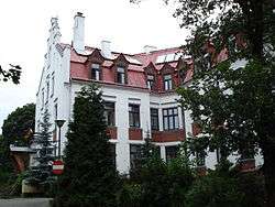
Retirement house in Zielonka
Nature
- Długa River
- 4 clay pits
- 2 nature reserves
- 86 trees registered as natural monuments
| Wikimedia Commons has media related to Zielonka. |
Coordinates: 52°18′03″N 21°09′31″E / 52.30083°N 21.15861°E
References
- ↑ Demographic Yearbook of Poland 2014 Archived 2016-02-20 at the Wayback Machine.
External links
- Jewish Community in Zielonka on Virtual Shtetl
Seat: Wołomin | ||
| Urban gminas |  | |
| Urban-rural gminas | ||
| Rural gminas | ||
This article is issued from
Wikipedia.
The text is licensed under Creative Commons - Attribution - Sharealike.
Additional terms may apply for the media files.