Zeller See (Lake Constance)
| Zeller See | |
|---|---|
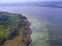 Zeller See, aerial photograph with view of the Hornspitze auf der Höri Nature Reserve near Gaienhofen looking towards Radolfzell | |
 Zeller See | |
| Location | Baden-Württemberg |
| Coordinates | 47°42′12″N 08°58′20″E / 47.70333°N 8.97222°ECoordinates: 47°42′12″N 08°58′20″E / 47.70333°N 8.97222°E |
| Part of | Untersee (Lake Constance) |
| Primary inflows | Radolfzeller Aach |
| Primary outflows | Rheinsee |
| Max. length | 5.4 km (3.4 mi) |
| Max. width | 2.35 km (1.46 mi) |
| Surface area | 11 km2 (4.2 sq mi) |
| Max. depth | 22 metres (72 ft) |
| Surface elevation | 395.3 m (1,297 ft) |
| Islands | Liebesinsel |
| Settlements | Radolfzell |
The Zeller See (Standard German of Germany; Swiss Standard German: Zellersee; could be translated as "Lake of Radolfzell") is part of the Lower Lake, the lower part of Lake Constance. It lies in the bay of Radolfzell, and between the peninsula of Mettnau to the north and the peninsula of Höri to the south. To the west it is bounded by the ried of the Radolfzeller Aach.[1]
The Zeller See has a maximum depth of 22 metres.[2]
See also
References
- ↑ Bodensee: Teilseen und Rheinmündung (Lake Constance: constituent lakes and confluence with the Rhine, map)
- ↑ ikgb Internationale Gewässerschutzkommission für den Bodensee: Limnologischer Zustand des Bodensees, Report No. 40, p. 43
External links
| Wikimedia Commons has media related to Zeller See (Lake Constance). |
This article is issued from
Wikipedia.
The text is licensed under Creative Commons - Attribution - Sharealike.
Additional terms may apply for the media files.