Zawidów
| Zawidów | ||
|---|---|---|
 City center | ||
| ||
 Zawidów  Zawidów | ||
| Coordinates: 51°1′N 15°4′E / 51.017°N 15.067°E | ||
| Country |
| |
| Voivodeship |
| |
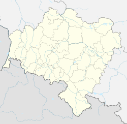
| County | Zgorzelec | |
| Gmina | Zawidów (urban gmina) | |
| Government | ||
| • Mayor | Józef Andrzej Sontowski | |
| Area | ||
| • Total | 6.07 km2 (2.34 sq mi) | |
| Elevation | 245 m (804 ft) | |
| Population (2006) | ||
| • Total | 4,412 | |
| • Density | 730/km2 (1,900/sq mi) | |
| Time zone | UTC+1 (CET) | |
| • Summer (DST) | UTC+2 (CEST) | |
| Postal code | 59-970 | |
| Car plates | DZG | |
| Website | http://miasto.zawidow.sisco.info | |
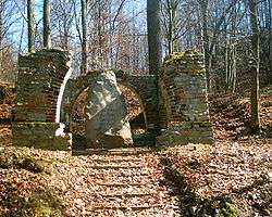
Imperial German World War 1 memorial in Zawidów
Zawidów [zaˈvʲiduf] (German: Seidenberg) is a town in Zgorzelec County, Lower Silesian Voivodeship, in south-western Poland, close to the Czech border. Prior to 1945 it was in Germany. (For more information about the history of the region, see Silesia.)
The town lies approximately 16 kilometres (10 mi) south of Zgorzelec, and 139 kilometres (86 mi) west of the regional capital Wrocław.
As at 2006, the town has a population of 4,412.
External links
| Urban gminas |  | |
|---|---|---|
| Urban-rural gminas | ||
| Rural gminas | ||
This article is issued from
Wikipedia.
The text is licensed under Creative Commons - Attribution - Sharealike.
Additional terms may apply for the media files.