Zatta (kebele in Ethiopia)
Coordinates: 12°18′13″N 39°10′23″E / 12.303546°N 39.172931°E
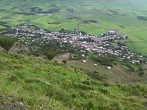
| Zatta ዛታ | ||
|---|---|---|
| Village | ||
 | ||
| ||
| Country | Ethiopia | |
| Region | Tigray | |
| Zone | Southern Tigray zone | |
| Elevation | 2,254 m (7,395 ft) | |
| Population (2007) | ||
| • Total | 15,546 | |
| Time zone | UTC+3 (EAT) | |

Zata (also ዛታ) is one of the sixteen kebeles (ጣብያ, the smallest administrative entity of the Tigray Region) within the wereda of Ofla in Ethiopia. Zata is bordered with amhara region with a river called Tslare ( ጽላረ) which flows into the Tekezé River.[1]
Zatta is located midway between korem and sekota. The main load that goes from Korem to sekota which is 100 km long crosses zatta at 35 km from korem.
References
This article is issued from
Wikipedia.
The text is licensed under Creative Commons - Attribution - Sharealike.
Additional terms may apply for the media files.