Zapolyarny District
| Zapolyarny District Заполярный район (Russian) | |
|---|---|
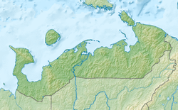 Zapolyarny District covers Nenets Autonomous Okrug, except for city of Naryan-Mar which is in the center, on the Pechora River. | |
| Coordinates: 67°40′N 53°08′E / 67.667°N 53.133°ECoordinates: 67°40′N 53°08′E / 67.667°N 53.133°E | |
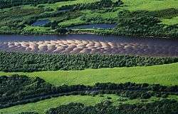 Pechora River, Zapolyarny District | |
 |
 |
|
| |
| Location | |
| Country | Russia |
| Federal subject | Nenets Autonomous Okrug[1] |
| Administrative structure (as of December 2015) | |
| Administrative center | work settlement of Iskateley[1] |
| Administrative divisions:[1] | |
| Urban-type settlements of district significance | 1 |
| Selsoviets | 17 |
| Inhabited localities:[1] | |
| Urban-type settlements[2] | 1 |
| Rural localities | 41 |
| Municipal structure (as of December 2015) | |
| Municipally incorporated as | Zapolyarny Municipal District[1] |
| Municipal divisions:[1] | |
| Urban settlements | 1 |
| Rural settlements | 18 |
| Statistics | |
| Area | 170,000 km2 (66,000 sq mi)[3] |
| Population (2010 Census) | 20,432 inhabitants[4] |
| • Urban | 33.7% |
| • Rural | 66.3% |
| Density | 0.12/km2 (0.31/sq mi)[5] |
| Time zone | MSK (UTC+03:00)[6] |
| Official website | |
Zapolyarny District (Russian: Заполя́рный райо́н) is an administrative and municipal district (raion), the only one in Nenets Autonomous Okrug, Russia.[1] It encompasses all of the territory of the autonomous okrug, with the exception of the territory of the town of okrug significance of Naryan-Mar, the only other top-level administrative division of the autonomous okrug.[1] The area of the district is approximately 170,000 square kilometers (66,000 sq mi).[3] Its administrative center is the urban locality (a work settlement) of Iskateley.[1] Population: 20,432 (2010 Census).[4] The population of Iskateley accounts for 33.7% of the district's total population.[4]
Etymology
The name of the district is an adjective which literally means "beyond the Arctic Circle", due to the fact that most of the district's territory indeed lies to the north of the Arctic Circle.[3]
History
Prior to 2010, the territory of the autonomous okrug had only one top-level administrative division—the town of okrug significance of Naryan-Mar—with the rest of the territory divided into selsoviets which were not a part of any top-level division. In 2006, within the framework of municipal divisions, the town of okrug significance of Naryan-Mar was incorporated as Naryan-Mar Urban Okrug, and the rest of the autonomous okrug's territory was incorporated as Zapolyarny Municipal District. However, it was not until April 19, 2010 when an administrative district matching the territory of the municipal district was established, and it was not until April 28, 2014 when "Zapolyarny" officially became the district's name.
Geography
The district stretches for about 320 kilometers (200 mi) from north to south and for 950 kilometers (590 mi) from east to west: from Cape Bolvansky Nos in the north to the source of the Oma River in the south, and from Cape Kanin Nos in the west to the banks of the Kara River in the east.[3]
Economy
The outer boundary of Zapolyarny District is identical to that of Nenets Autonomous Okrug; therefore there is no economic sector of significance to the district that is not also of equal significance to the autonomous okrug. The main economic drivers are oil and gas,[7] although reindeer husbandry is still seen as a core part of the culture of the indigenous Nenets people.[8]
References
Notes
- 1 2 3 4 5 6 7 8 9 Law #557-OZ
- ↑ The count of urban-type settlements may include the work settlements, the resort settlements, the suburban (dacha) settlements, as well as urban-type settlements proper.
- 1 2 3 4 Official website of Zapolyarny District. Background Notes Archived March 5, 2012, at the Wayback Machine. (in Russian)
- 1 2 3 Russian Federal State Statistics Service (2011). "Всероссийская перепись населения 2010 года. Том 1" [2010 All-Russian Population Census, vol. 1]. Всероссийская перепись населения 2010 года (2010 All-Russia Population Census) (in Russian). Federal State Statistics Service. Retrieved June 29, 2012.
- ↑ The value of density was calculated automatically by dividing the 2010 Census population by the area specified in the infobox. Please note that this value is only approximate as the area specified in the infobox does not necessarily correspond to the area of the entity proper or is reported for the same year as the population.
- ↑ Правительство Российской Федерации. Федеральный закон №107-ФЗ от 3 июня 2011 г. «Об исчислении времени», в ред. Федерального закона №271-ФЗ от 03 июля 2016 г. «О внесении изменений в Федеральный закон "Об исчислении времени"». Вступил в силу по истечении шестидесяти дней после дня официального опубликования (6 августа 2011 г.). Опубликован: "Российская газета", №120, 6 июня 2011 г. (Government of the Russian Federation. Federal Law #107-FZ of June 31, 2011 On Calculating Time, as amended by the Federal Law #271-FZ of July 03, 2016 On Amending Federal Law "On Calculating Time". Effective as of after sixty days following the day of the official publication.).
- ↑ The Norwegian Barents Secretariat - Barents Monitoring, Nenets Autonomous Okrug, First Quarter, 2009
- ↑ T. Tuuisku, Transition Period in the Nenets Autonomous Okrug: Changing and Unchanging Life of Nenets People. First published in: ed. E. Kasten, People and the Land: Pathways to Reform in Post-Soviet Siberia, 2002, p.189-205. Berlin: Dietrich Reimer Verlag
Sources
- Собрание депутатов Ненецкого автономного округа. Закон №557-ОЗ от 24 февраля 2005 г. «Об административно-территориальном устройстве Ненецкого автономного округа», в ред. Закона №155-ОЗ от 1 декабря 2015 г. «О внесении изменений в часть 1 статьи 2 Закона Ненецкого автономного округа "Об административно-территориальном устройстве Ненецкого автономного округа"». Вступил в силу со дня официального опубликования. Опубликован: "Няръяна Вындер", №28, 28 февраля 2005 г. (Council of Deputies of Nenets Autonomous Okrug. Law #557-OZ of February 24, 2005 On the Administrative-Territorial Structure of Nenets Autonomous Okrug, as amended by the Law #155-OZ of December 1, 2015 On Amending Part 1 of Article 2 of the Law of Nenets Autonomous Okrug "On the Administrative-Territorial Structure of Nenets Autonomous Okrug". Effective as of the day of the official publication.).