Zandvoorde, Zonnebeke
| Zandvoorde | |
|---|---|
| Deelgemeente | |
 | |
| Coordinates: 50°48′46″N 2°58′52″E / 50.81278°N 2.98111°ECoordinates: 50°48′46″N 2°58′52″E / 50.81278°N 2.98111°E | |
| Country | Belgium |
| Province |
|
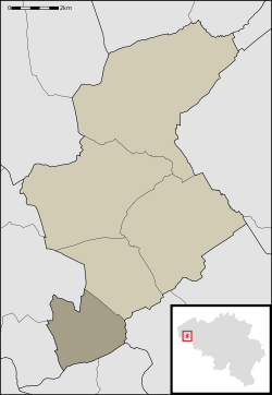
| Municipality | Zonnebeke |
| Area | |
| • Total | 6.68 km2 (2.58 sq mi) |
| Population (1999) | |
| • Total | 474 |
| Source: NIS | |
| Postal code | 8980 |
Zandvoorde (West Flemish: Zanvôorde) is a village in the Belgian province of West Flanders and a part (deelgemeente) of the municipality of Zonnebeke. Zandvoorde is a rural village, in the rolling landscape of the southern part of the province.
_-_Skyline.jpg)
View on Zandvoorde
History
Old listings of the place date back to 1102, as Sanfort. "Sant" refers to sand (in modern Dutch: zand), "fort" refers to Ford (in modern Dutch: voorde), a shallow crossing in a watercourse.
The village was completely destroyed during World War I.
Landmarks
- The Parish and its church are named after Saint Bartholomew. The current church dates from 1923–1925, after the old church had been destroyed during the First World War.
- The Zantvoorde New British Cemetery is a Commonwealth War Graves Commission World War I military cemetery. In the village centre, there is a British war memorial, The Household Cavalry Monument.
Trivia
- In the north of the province of West Flanders, there's another village with the name Zandvoorde, a part of the city of Oostende
| Wikimedia Commons has media related to Zandvoorde, Zonnebeke. |
This article is issued from
Wikipedia.
The text is licensed under Creative Commons - Attribution - Sharealike.
Additional terms may apply for the media files.