Zaber
| Zaber | |
|---|---|
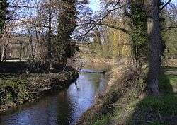 Zaber at its confluence with the Neckar at Lauffen am Neckar. | |
| Country | Germany |
| Physical characteristics | |
| Main source |
Near Zaberfeld 316 m (1,037 ft) |
| River mouth |
Neckar at Lauffen am Neckar 49°04′43″N 9°09′18″E / 49.0785°N 9.1550°ECoordinates: 49°04′43″N 9°09′18″E / 49.0785°N 9.1550°E |
| Length | 22.5 km (14.0 mi) [1] |
| Basin features | |
| Progression | Neckar→ Rhine→ North Sea |
The ![]()
Course
The Zaber rises in the Stromberg to the south of the town of Zaberfeld and flows initially into a reservoir known as the Ehmetsklinge. It subsequently flows in an easterly direction through Zaberfeld, Pfaffenhofen, Güglingen and Brackenheim before reaching the Neckar at Lauffen. The river is shallow and therefore not navigable.
References
This article is issued from
Wikipedia.
The text is licensed under Creative Commons - Attribution - Sharealike.
Additional terms may apply for the media files.