Złoty Stok
| Złoty Stok | ||
|---|---|---|
 | ||
| ||
 Złoty Stok | ||
| Coordinates: 50°26′47″N 16°52′59″E / 50.44639°N 16.88306°E | ||
| Country |
| |
| Voivodeship | Lower Silesian | |
| County | Ząbkowice Śląskie | |
| Gmina | Złoty Stok | |
| Area | ||
| • Total | 7.73 km2 (2.98 sq mi) | |
| Population (2006) | ||
| • Total | 2,930 | |
| • Density | 380/km2 (980/sq mi) | |
| Postal code | 57-250 | |
| Website | http://www.zlotystok.pl | |
Złoty Stok [ˈzwɔtɨ ˈstɔk] (German: Reichenstein, Czech: Rychleby, "Richstone") is a town in Ząbkowice Śląskie County, Lower Silesian Voivodeship, in south-western Poland. It is situated on the border with the Czech Republic, adjoining the Czech village Bílá Voda.
The name Złoty Stok means "golden slope" in Polish and is a reference to the fact that a gold deposit was mined here in the Middle Ages.
The town is the seat of the administrative district (gmina) called Gmina Złoty Stok, and lies approximately 16 kilometres (10 mi) south of Ząbkowice Śląskie and 77 kilometres (48 mi) south of the regional capital Wrocław. Prior to 1945 Złoty Stok was in Germany and after World War II it became part of the Polish Recovered Territories.
Złoty Stok, then Reichenstein, was, for many prisoners of war, a stopping place on 'The Long March' during the final months of the Second World War in Europe. About 30,000 Allied PoWs were force-marched westward across Poland, Czechoslovakia and Germany in appalling winter conditions, lasting about four months from January to April 1945.[1]
As at 2006, the town has a population of 2,930.
Its Czech name is applied to the neighbouring mountain range, the Rychleby Mountains (Czech: Rychlebské hory). The corresponding Polish name is Góry Złote (Golden Mountains). This range is part of the eastern Sudetes.
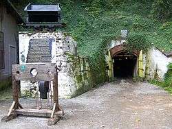
There is a number of historical monuments in the town, including a museum of gold mining and metallurgy (Muzeum Górnictwa i Hutnictwa Złota w Złotym Stoku).[2] The first evidence of mining in Złoty Stok dates from the first millennium AD. At the beginning of the 16th century the town, called Reichenstein (Richstone) by the Germans, began to flower thanks to the mining and working of gold. The search for this precious ore continued until the closing of the mine in the late 1960s, even though it had not fully rendered all its wealth.
References
| Wikimedia Commons has media related to Złoty Stok. |
| Town and seat |  | |
|---|---|---|
| Villages | ||
Coordinates: 50°26′47″N 16°52′59″E / 50.44639°N 16.88306°E