Yonah, Georgia
| Yonah, Georgia | |
|---|---|
| Census-designated place (CDP) & Unincorporated Community | |
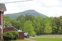 Yonah Mountain viewed from Mount Yonah Baptist Church | |
 Yonah, Georgia | |
| Coordinates: 34°38′28″N 83°45′13″W / 34.64111°N 83.75361°WCoordinates: 34°38′28″N 83°45′13″W / 34.64111°N 83.75361°W | |
| Country | United States |
| State | Georgia |
| County | White |
| Area[1] | |
| • Total | 3.149 sq mi (8.16 km2) |
| • Land | 3.123 sq mi (8.09 km2) |
| • Water | 0.026 sq mi (0.07 km2) |
| Elevation | 1,539 ft (469 m) |
| Population (2010) | |
| • Total | 507 |
| • Density | 160/sq mi (62/km2) |
| Time zone | UTC-5 (Eastern (EST)) |
| • Summer (DST) | UTC-4 (EDT) |
| Area code(s) | 706 & 762 |
| GNIS feature ID | 333482[2] |
Yonah is a census-designated place and unincorporated community in White County, Georgia, United States. Its population was 507 as of the 2010 census.[1] Georgia State Route 75 passes through the community.
References
| Wikimedia Commons has media related to Yonah, Georgia. |
- 1 2 "2010 Census Gazetteer Files - Places: Georgia". U.S. Census Bureau. Retrieved January 4, 2015.
- ↑ "Yonah". Geographic Names Information System. United States Geological Survey.
Municipalities and communities of White County, Georgia, United States | ||
|---|---|---|
| Cities | 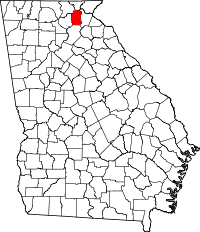 | |
| CDPs | ||
| Unincorporated communities | ||
This article is issued from
Wikipedia.
The text is licensed under Creative Commons - Attribution - Sharealike.
Additional terms may apply for the media files.