Yeongdo District
| Yeongdo 영도구 | ||
|---|---|---|
| Autonomous District | ||
| Korean transcription(s) | ||
| • Hanja | 影島區 | |
| • Revised Romanization | Yeongdo-gu | |
| • McCune-Reischauer | Yǒngdo-ku | |
 | ||
| ||
 | ||
| Country | South Korea | |
| Region | Yeongnam | |
| Provincial level | Busan | |
| Administrative divisions | 11 administrative dong | |
| Area | ||
| • Total | 14.15 km2 (5.46 sq mi) | |
| Population (2017[1]) | ||
| • Total | 124,026 | |
| • Density | 8,800/km2 (23,000/sq mi) | |
| • Dialect | Gyeongsang | |
| Website | Yeongdo District Office | |
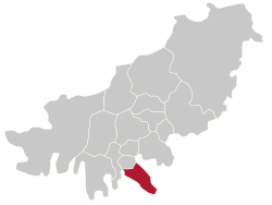
Yeongdo District is a gu in Busan, South Korea. The gu itself is limited to Yeong-do (Yeong Island) located on the south edge of central Busan. It attained the status of gu in 1957.
The Korea Maritime and Ocean University and the National Maritime Museum of Korea are located in Yeongdo-gu.
Origin of the Name "Yeongdo"
The former name of Yeong-do (Yeong Island) was Jeolyeong-do (Jeolyeong Island).
Mythologically, horses that could run a thousand miles, so-called "Chollima", lived on this island. Because the horses living on this island could run so fast that their shadows could not follow them, this island was called, "Jeolyeong-do".
After the South Korea government arranged their administrative divisions' names, the name of the island was changed to, "Yeongdo-gu. [2]
Administrative divisions
Yeongdo-gu is divided into 22 legal dong, which altogether comprise 11 administrative dong, as follows:
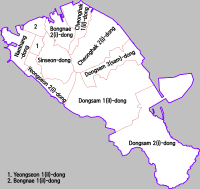
| Legal dong | Administrative dong |
|---|---|
| Namhang-dong 1-ga | Namhang-dong |
| Namhang-dong 2-ga | |
| Namhang-dong 3-ga | |
| Daegyo-dong 1-ga | |
| Daegyo-dong 2-ga | |
| Daepyeong-dong 1-ga | |
| Daepyeong-dong 2-ga | |
| Daepyeong-dong 3-ga | |
| Yeongseon-dong 1-ga | Yeongseon 1-dong |
| Yeongseon-dong 2-ga | |
| Yeongseon-dong 3-ga | Yeongseon 2-dong |
| Yeongseon-song 4-ga | |
| Sinseon-dong 1-ga | Sinseon-dong |
| Sinseon-dong 2-ga | |
| Sinseon-dong 3-ga | |
| Bongnae-dong 1-ga | Bongnae 1-dong |
| Bongnae-dong 2-ga | |
| Bongnae-dong 3-ga | |
| Bongnae-dong 4-ga | Bongnae 2-dong |
| Bongnae-dong 5-ga | |
| Cheonghak-dong | Cheonghak 1-dong |
| Cheonghak 2-dong | |
| Dongsam-dong | Dongsam 1-dong |
| Dongsam 2-dong | |
| Dongsam 3-dong |
Sister cities
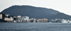
Cityscape


 Nighttime in Yeongdo
 West Side of Yeongdo
See also
References
External links
| Wikimedia Commons has media related to Yeongdo-gu, Busan. |
- Yeongdo-gu website (in English)
Coordinates: 35°04′50″N 129°03′50″E / 35.08056°N 129.06389°E