Yatsuka, Okayama
| Yatsuka 八束村 | |
|---|---|
| Former municipality | |
 Yatsuka Location in Japan | |
| Coordinates: 35°17′13.4″N 133°42′3.7″E / 35.287056°N 133.701028°ECoordinates: 35°17′13.4″N 133°42′3.7″E / 35.287056°N 133.701028°E | |
| Country | Japan |
| Region | Chūgoku |
| Prefecture | Okayama Prefecture |
| District | Maniwa |
| Merged |
March 31, 2005 (now part of Maniwa) |
| Area | |
| • Total | 61.19 km2 (23.63 sq mi) |
| Population (2003) | |
| • Total | 2,946 |
| • Density | 48.15/km2 (124.7/sq mi) |
| Symbols | |
| • Tree | Ginkgo biloba |
| • Flower | Menyanthes |
| • Bird | Japanese bush-warbler |
| Time zone | UTC+9 (JST) |
Yatsuka (八束村 Yatsuka-son) was a town located in Maniwa District, Okayama Prefecture, Japan.
As of 2003, the village had an estimated population of 2,946 and a density of 48.15 persons per km2. The total area was 61.19 km2.
On March 31, 2005, Yatsuka, along with the town of Hokubō (from Jōbō District), and towns of Katsuyama, Kuse, Ochiai and Yubara, and the villages of Chūka, Kawakami and Mikamo (all from Maniwa District) were merged to create the city of Maniwa.
Geography
- Mountains: Mount Hiruzen (蒜山 Hiruzen)
- Rivers: Asahi River (The big-3 river through Okayama Prefecture)
Adjoining municipalities
Economy
Agriculture
Education
- Yatsuka Elementary School
- Hiruzen Junior High School
- Okayama Prefectural Hiruzen High School
Transportation
- Expressways:
- Yonago Expressway
- Hiruzen Interchange (Kawakami)
- Yonago Expressway
- National highways:
- Prefectural roads:
- Okayama Prefectural Route 324 (Higashikayabe-Shimofukuda)
- Okayama Prefectural Route 325 (Bessho-Shimonagata)
- Okayama Prefectural Route 422 (Hiruzen Kōgen)
- Okayama Prefectural Route 702 (Yatsuka-Kawakami cycling road)
- Roadside Station
- Hiruzen Kōgen
Notable places and events
- Mount Hiruzen
- Hiruzen plateau (蒜山高原 Hiruzen Kōgen)
- Hiruzen Jersey Land
- Kamihiruzen Ski resort
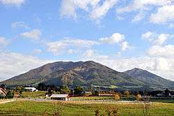 Mount Hiruzen
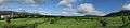 Hiruzen plateau
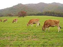 Hiruzen Jersey Land
External links
- Official website of Maniwa in Japanese
This article is issued from
Wikipedia.
The text is licensed under Creative Commons - Attribution - Sharealike.
Additional terms may apply for the media files.