Yanarrajo
| Yanarrajo | |
|---|---|
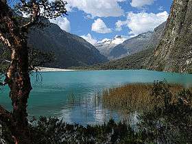 The Llanganuco Lakes with the snow-covered Yanapaccha in the background and the snowless Yanarrajo on the right | |
| Highest point | |
| Elevation | 5,055 m (16,585 ft) [1] |
| Coordinates | 9°02′14″S 77°35′16″W / 9.03722°S 77.58778°WCoordinates: 9°02′14″S 77°35′16″W / 9.03722°S 77.58778°W |
| Geography | |
 Yanarrajo Peru | |
| Location | Peru, Ancash Region |
| Parent range | Andes, Cordillera Blanca |
Yanarrajo[2][3] (possibly from Quechua yana black,[4] rahu snow, ice, mountain with snow,[5] "black snow peak" is a mountain in the Cordillera Blanca in the Andes of Peru, about 5,055 metres (16,585 ft) high. It is situated in the Ancash Region, Yungay Province, in the districts Yanama and Yungay.[3] Yanarrajo lies in the Huascarán National Park, south-west of Yanapaccha, near the Llanganuco Lakes.[2]
References
- ↑ mapcarta.com "Cerro Yanarrajo", retrieved on May 8, 2013
- 1 2 Peru 1:100 000, Carhuás (19-h). IGN (Instituto Geográfico Nacional - Perú).
- 1 2 escale.minedu.gob.pe - UGEL map of the Yungay Province (Ancash Region) showing "Cerro Yanarrajo"
- ↑ Teofilo Laime Acopa, Diccionario Bilingüe, Iskay simipi yuyay k'ancha, Quechua – Castellano, Castellano – Quechua: yana - adj. Negro, -gra. De color muy oscuro. || Oscuro, -ra. Que carece de luz o claridad.
- ↑ babylon.com
| Wikimedia Commons has media related to Cordillera Blanca. |
This article is issued from
Wikipedia.
The text is licensed under Creative Commons - Attribution - Sharealike.
Additional terms may apply for the media files.