Yair Bridge
| Yair Bridge | |
|---|---|
.jpg) | |
| Coordinates | 55°35′10″N 2°52′10″W / 55.586°N 2.8695°WCoordinates: 55°35′10″N 2°52′10″W / 55.586°N 2.8695°W |
| Carries | A707 public road |
| Crosses | River Tweed |
| Heritage status | Category A listed |
| Characteristics | |
| Material | Stone |
| Total length | 146 feet (45 m) |
| No. of spans | 3 |
| Clearance below | 22 feet (6.7 m) |
| History | |
| Designer | William Mylne |
| Opened | 1764 |
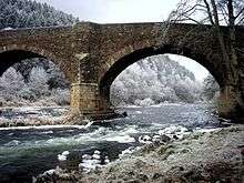
The Yair Bridge or Fairnilee Bridge is a bridge across the River Tweed at Yair, near Galashiels in the Scottish Borders.
History
It was built in around 1764, with William Mylne acting as both designer and contractor.[1] Its construction was authorised by an Act of Parliament obtained in 1764, for 12 miles (19 km) of road that would cost 6560l, including the "substantial" bridge at Fairnilee.[2]
It was listed as a Category A listed building in 1971.[3]
The bridge was substantially rebuilt between 1987 and 1988, with the addition of reinforcing concrete.[4]
Design
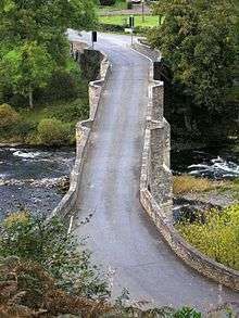
It has three arches of 42 feet (13 m) span, and is 22 feet (6.7 m) clear over the river.[4] The total length of the bridge is 146 feet (45 m).[4] The width between the parapets is 13 feet 9 inches (4.19 m), but the cutwaters are carried up to form semi-hexagonal pedestrian refuges.[4] The piers and abutments are made from block masonry, and the rest of the structure is made from rubble.[4]
The bridge carries the A707 public road across the River Tweed.[5]
References
- ↑ Skempton, A. W. (2002). A Biographical Dictionary of Civil Engineers in Great Britain and Ireland: 1500-1830. Thomas Telford. p. 473. ISBN 978-0-7277-2939-2.
- ↑ Douglas, Robert (1798). General View of the Agriculture of the Counties of Roxburgh and Selkirk; with Observations on the Means of Its Improvement. Richard Phillips. p. 322.
- ↑ "Yair Bridge (Ref: 1901)". historic-scotland.gov.uk. Retrieved 16 March 2015.
- 1 2 3 4 5 "Yair Bridge". rcahms.gov.uk. Retrieved 16 March 2015.
- ↑ Google (16 March 2015). "Yair Bridge" (Map). Google Maps. Google. Retrieved 16 March 2015.
External links
| Wikimedia Commons has media related to Yair Bridge. |