Woroba District
| Woroba District District du Woroba | |
|---|---|
| District | |
 | |
| Country |
|
| Established | 2011 |
| Capital | Séguéla |
| Area[1] | |
| • Total | 31,088 km2 (12,003 sq mi) |
| Population (2014)[2] | |
| • Total | 845,139 |
| • Density | 27/km2 (70/sq mi) |
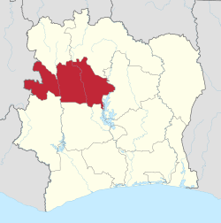
Woroba District (French: District du Woroba) is one of fourteen administrative districts of Ivory Coast. The district is located in the northeast part of the country. The capital of the district is Séguéla.
Creation
Woroba District was created in a 2011 administrative reorganisation of the subdivisions of Ivory Coast.[3] The territory of the district was composed by merging the regions of Bafing and Worodougou.[1]
Administrative divisions
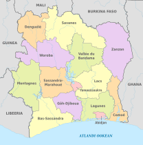
Woroba District is currently subdivided into three regions and the following departments:
- Bafing Region (region seat in Touba)
- Béré Region (region seat in Mankono)
- Worodougou Region (region seat also in Séguéla)
Population
According to the 2014 census, Woroba District has a population of 845,139, making it the third least populous district in Ivory Coast, behind Denguélé District and Yamoussoukro Autonomous District.[2]
References
- 1 2 "Districts of Côte d'Ivoire (Ivory Coast)". Statoids.com. Retrieved 24 June 2015.
- 1 2 "Côte d'Ivoire". GeoHive.com. Retrieved 24 June 2015.
- ↑ Décret n° 2011-263 du 28 septembre 2011 portant organisation du territoire national en Districts et en Régions.
 | ||
AD = Autonomous District | ||
This article is issued from
Wikipedia.
The text is licensed under Creative Commons - Attribution - Sharealike.
Additional terms may apply for the media files.