Wooragee
| Wooragee Victoria | |
|---|---|
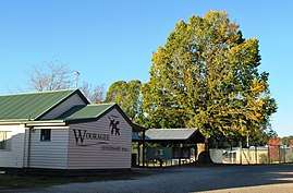 Centenary Hall at Wooragee, 2009 | |
 Wooragee | |
| Coordinates | 36°17′25″S 146°43′48″E / 36.29028°S 146.73000°ECoordinates: 36°17′25″S 146°43′48″E / 36.29028°S 146.73000°E |
| Population | 345 (2016 census)[1] |
| Postcode(s) | 3747 |
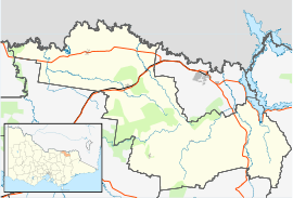
| Location |
|
| LGA(s) | Shire of Indigo |
| State electorate(s) | Benambra |
| Federal Division(s) | Indi |
Wooragee is a locality in north east Victoria, Australia. The locality is in the Shire of Indigo local government area, 295 kilometres (183 mi) north east of the state capital, Melbourne.
At the 2016 census, Wooragee had a population of 345.[1]
References
- 1 2 Australian Bureau of Statistics (27 June 2017). "Wooragee". 2016 Census QuickStats. Retrieved 6 August 2017.

External links
![]()
This article is issued from
Wikipedia.
The text is licensed under Creative Commons - Attribution - Sharealike.
Additional terms may apply for the media files.