Wong Tai Sin station
Wong Tai Sin 黃大仙 | ||||||||||||||||||||||||||||||||||||||||||||||||||||||||||||||||||||||||||||||||
|---|---|---|---|---|---|---|---|---|---|---|---|---|---|---|---|---|---|---|---|---|---|---|---|---|---|---|---|---|---|---|---|---|---|---|---|---|---|---|---|---|---|---|---|---|---|---|---|---|---|---|---|---|---|---|---|---|---|---|---|---|---|---|---|---|---|---|---|---|---|---|---|---|---|---|---|---|---|---|---|---|
| MTR rapid transit station | ||||||||||||||||||||||||||||||||||||||||||||||||||||||||||||||||||||||||||||||||
 Platform 1 | ||||||||||||||||||||||||||||||||||||||||||||||||||||||||||||||||||||||||||||||||
| Chinese name | ||||||||||||||||||||||||||||||||||||||||||||||||||||||||||||||||||||||||||||||||
| Traditional Chinese | 黃大仙 | |||||||||||||||||||||||||||||||||||||||||||||||||||||||||||||||||||||||||||||||
| Simplified Chinese | 黄大仙 | |||||||||||||||||||||||||||||||||||||||||||||||||||||||||||||||||||||||||||||||
| Cantonese Yale | Wòngdaaihsīn | |||||||||||||||||||||||||||||||||||||||||||||||||||||||||||||||||||||||||||||||
| Hanyu Pinyin | Huángdàxiān | |||||||||||||||||||||||||||||||||||||||||||||||||||||||||||||||||||||||||||||||
| ||||||||||||||||||||||||||||||||||||||||||||||||||||||||||||||||||||||||||||||||
| General information | ||||||||||||||||||||||||||||||||||||||||||||||||||||||||||||||||||||||||||||||||
| Location |
Lung Cheung Road near Wong Tai Sin Centre, Wong Tai Sin Wong Tai Sin District, Hong Kong | |||||||||||||||||||||||||||||||||||||||||||||||||||||||||||||||||||||||||||||||
| Coordinates | 22°20′30″N 114°11′38″E / 22.3417°N 114.1939°ECoordinates: 22°20′30″N 114°11′38″E / 22.3417°N 114.1939°E | |||||||||||||||||||||||||||||||||||||||||||||||||||||||||||||||||||||||||||||||
| Operated by | MTR Corporation | |||||||||||||||||||||||||||||||||||||||||||||||||||||||||||||||||||||||||||||||
| Line(s) | ||||||||||||||||||||||||||||||||||||||||||||||||||||||||||||||||||||||||||||||||
| Platforms | 2 (island platform) | |||||||||||||||||||||||||||||||||||||||||||||||||||||||||||||||||||||||||||||||
| Connections | Bus, public light bus | |||||||||||||||||||||||||||||||||||||||||||||||||||||||||||||||||||||||||||||||
| Construction | ||||||||||||||||||||||||||||||||||||||||||||||||||||||||||||||||||||||||||||||||
| Structure type | Underground | |||||||||||||||||||||||||||||||||||||||||||||||||||||||||||||||||||||||||||||||
| Platform levels | 1 | |||||||||||||||||||||||||||||||||||||||||||||||||||||||||||||||||||||||||||||||
| Disabled access | Yes | |||||||||||||||||||||||||||||||||||||||||||||||||||||||||||||||||||||||||||||||
| Other information | ||||||||||||||||||||||||||||||||||||||||||||||||||||||||||||||||||||||||||||||||
| Station code | WTS | |||||||||||||||||||||||||||||||||||||||||||||||||||||||||||||||||||||||||||||||
| History | ||||||||||||||||||||||||||||||||||||||||||||||||||||||||||||||||||||||||||||||||
| Opened |
| |||||||||||||||||||||||||||||||||||||||||||||||||||||||||||||||||||||||||||||||
| Services | ||||||||||||||||||||||||||||||||||||||||||||||||||||||||||||||||||||||||||||||||
|
| ||||||||||||||||||||||||||||||||||||||||||||||||||||||||||||||||||||||||||||||||
| ||||||||||||||||||||||||||||||||||||||||||||||||||||||||||||||||||||||||||||||||
| Location | ||||||||||||||||||||||||||||||||||||||||||||||||||||||||||||||||||||||||||||||||
|
Wong Tai Sin Location within the MTR system | ||||||||||||||||||||||||||||||||||||||||||||||||||||||||||||||||||||||||||||||||
Wong Tai Sin (Chinese: 黃大仙; Cantonese Yale: Wòngdaaihsīn) is a station on the Hong Kong MTR Kwun Tong Line. It is named after the Wong Tai Sin Temple, which is managed by Taoist organisation Sik Sik Yuen.
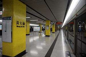
Livery
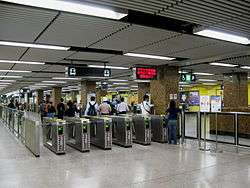
Wong Tai Sin Station Concourse
The station's livery is yellow to reflect the character "Wong" in Chinese (黃), which means "yellow"[1]
Station layout
Platforms 1 and 2 share the same island platform.
| G | Ground level | Exits |
| C | Concourse | Customer service, MTRshops, vending machines |
| Hang Seng Bank, automatic teller machines | ||
| P Platforms |
Platform 1 | Kwun Tong line towards Tiu Keng Leng (Diamond Hill) → |
| Island platform, doors will open on the right | ||
| Platform 2 | ← Kwun Tong line towards Whampoa (Lok Fu) | |
Entrances/exits
- A/E: Lung Cheung Road (West Exit)
- B1/B2: Lung Cheung Road (East Exit)
- B3: Wong Tai Sin Temple, Temple Mall North

- C1: Ching Tak Street/Lung Cheung Road Junction
- C2: Ching Tak Street
- D1: San Po Kong
- D2: Ching Tak Street, Bus Terminus
- D3: Temple Mall South[3]
Transport connections
Minibus routes
- 37M (Exit A) to Tsz Wan Shan
- 38M (Exit A) to Chuk Yuen Estate
- 33M (Exit C2) to Fu Shan Estate
- 79M (Exit D2) to King Tung Street
- 20M (Exit D2) to San Po Kong
Bus routes
- 85M (Exit D2) to Kam Ying Court
- 80 (Exit D1) to Mei Lam
- 89B (Exit D1) to Sha Tin Wai
- 211 (Exit B1) to Tsui Chuk Garden
- 2F, 3C (Exit B1) to Tsz Wan Shan
- 113 (Exit D1) to Kennedy Town (Belcher's Bay)
References
- ↑ Ben Pang (17 November 2016). "Why are Hong Kong's MTR stations different colours? Central is red for a reason, and why Prince Edward is purple might surprise you". South China Morning Post.
- ↑ "Wong Tai Sin Station layout" (PDF). MTR Corporation. Retrieved 27 July 2014.
- ↑ "Wong Tai Sin Station street map" (PDF). MTR Corporation. Retrieved 27 July 2014.
This article is issued from
Wikipedia.
The text is licensed under Creative Commons - Attribution - Sharealike.
Additional terms may apply for the media files.