Winslow–Lindbergh Regional Airport
| Winslow–Lindbergh Regional Airport Winslow Municipal Airport | |||||||||||||||
|---|---|---|---|---|---|---|---|---|---|---|---|---|---|---|---|
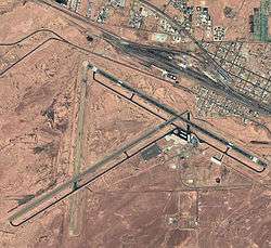 USGS aerial photo, 1997 | |||||||||||||||
| Summary | |||||||||||||||
| Airport type | Public | ||||||||||||||
| Owner | City of Winslow | ||||||||||||||
| Serves | Winslow, Arizona | ||||||||||||||
| Elevation AMSL | 4,941 ft / 1,506 m | ||||||||||||||
| Coordinates | 35°01′19″N 110°43′21″W / 35.02194°N 110.72250°W | ||||||||||||||
| Map | |||||||||||||||
 KINW  KINW | |||||||||||||||
| Runways | |||||||||||||||
| |||||||||||||||
| Statistics (2009) | |||||||||||||||
| |||||||||||||||
Winslow–Lindbergh Regional Airport (IATA: INW, ICAO: KINW, FAA LID: INW) is 1 mile (0.87 nmi; 1.6 km) mile west of Winslow, in Navajo County, Arizona.[1] The U.S. Forest Service has a firefighting Air Tanker base here. The airport was served by TWA and Frontier Airlines but now sees no airline service.
History
The airport was built in 1929 by Transcontinental Air Transport (TAT). Aviator Charles Lindbergh, who served as head of TAT's Technical Committee, chose Winslow as one of twelve critical refueling stops on the nation's first transcontinental passenger line. For many years it was the only all weather airport between Albuquerque, New Mexico,and Los Angeles, CA. During World War II the airfield was used by the United States Army Air Forces Air Transport Command as a refueling and repair stop for military aircraft.[2] The airport is dedicated to the memory of Melvin L. Kislingbury, a Winslow resident who was killed in a WW II flight mission in Louisiana in 1943.[3] TWA's last scheduled flight to Winslow was in 1953. Arizona Airways served the city in the late 1940s and merged to become Frontier Airlines in 1950. Frontier served Winslow as one of several stops along a Denver to Phoenix route and service continued until 1974. The city was then served by several commuter airlines with flights to Phoenix until the late 1980s. These commuters include Cochise Airlines, Desert Airlines, Sun West Airlines, and Golden Pacific Airlines.[4]
Facilities
The airport covers 900 acres (360 ha) at an elevation of 4,941 feet (1,506 m). It has two asphalt runways:
- 4/22 is 7,499 by 150 feet (2,286 x 46 m)
- 11/29 is 7,100 by 150 feet (2,164 x 46 m).[1]
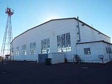
In the year ending April 18, 2009 the airport had 19,250 aircraft operations, an average of 52 per day: 99% general aviation and 1% military. 11 aircraft were then based at this airport: 64% single-engine, 27% multi-engine and 9% helicopter.[1] Winslow Airport is served by Wiseman Aviation as a FBO and is regularly visited by Cooper Aerial an aerial photography firm.
References
| Wikimedia Commons has media related to Winslow–Lindbergh Regional Airport. |
- 1 2 3 4 FAA Airport Master Record for INW (Form 5010 PDF). Federal Aviation Administration. Effective 29 July 2010.
- ↑

- ↑ History of the Winslow–Lindbergh Regional Airport
- ↑ Airline timetables
External links
- Winslow~Lindberg Regional Airport (INW) at Arizona DOT airport directory
- FAA Terminal Procedures for INW, effective October 11, 2018
- Resources for this airport:
- FAA airport information for INW
- AirNav airport information for KINW
- ASN accident history for INW
- FlightAware airport information and live flight tracker
- NOAA/NWS latest weather observations
- SkyVector aeronautical chart, Terminal Procedures