Wilson's Bridge
|
Wilson's Bridge | |
 | |
  | |
| Location | U.S. Route 40, Hagerstown, Maryland |
|---|---|
| Coordinates | 39°39′27″N 77°50′53″W / 39.65750°N 77.84806°WCoordinates: 39°39′27″N 77°50′53″W / 39.65750°N 77.84806°W |
| Area | less than one acre |
| Built | 1819 |
| Built by | Silas Harry |
| NRHP reference # | 82002822[1] |
| Added to NRHP | March 15, 1982 |
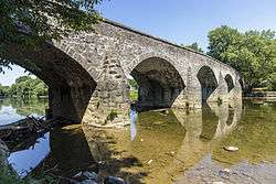
Wilson's Bridge is a bridge near Hagerstown, Washington County, Maryland, United States. It originally carried the Hagerstown and Conococheague Turnpike, the National Road, across Conococheague Creek 7 miles (11 km) west of Hagerstown. The five-arched structure, the longest of the county's stone bridges, is 210 feet (64 m) in length and is constructed of coursed local limestone. The bridge was erected in 1819 by Silas Harry, who had built similar bridges in Pennsylvania. The bridge was closed in June 1972 when it was damaged by floods which occurred during Tropical Storm Agnes.[2]
Wilson's Bridge was listed on the National Register of Historic Places in 1982.[1]
See also
References
- 1 2 National Park Service (2010-07-09). "National Register Information System". National Register of Historic Places. National Park Service.
- ↑ Paula Stoner Reed (March 1981). "National Register of Historic Places Registration: Wilson's Bridge" (PDF). Maryland Historical Trust. Retrieved 2016-01-01.
External links
- Wilson's Bridge, Washington County, including photo from 1984, at Maryland Historical Trust
- Historic American Engineering Record (HAER) No. MD-41, "National Road, Wilson Bridge, Spanning Conococheague Creek at Route 40 (Old), Hagerstown, Washington County, MD", 17 photos, 2 measured drawings, 19 data pages, 2 photo caption pages
- Historic American Buildings Survey (HABS) No. MD-139-A, "Bridge over Conococheague River, Old National Trail, Hagerstown, Washington County, MD", 2 photos
| Topics |  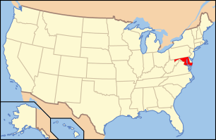 | |
|---|---|---|
| Lists by county | ||
| Lists by city | ||
| Other lists | ||
| ||
This article is issued from
Wikipedia.
The text is licensed under Creative Commons - Attribution - Sharealike.
Additional terms may apply for the media files.