Wil, Aargau
| Wil | ||
|---|---|---|
| Former municipality of Switzerland | ||
| ||
 Wil | ||
|
Location of Wil 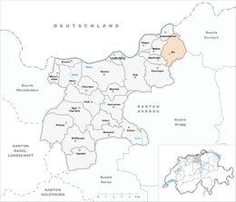 Wil Wil (Canton of Aargau) | ||
| Coordinates: 47°34′N 8°9′E / 47.567°N 8.150°ECoordinates: 47°34′N 8°9′E / 47.567°N 8.150°E | ||
| Country | Switzerland | |
| Canton | Aargau | |
| District | Laufenburg | |
| Area | ||
| • Total | 7.71 km2 (2.98 sq mi) | |
| Elevation | 381 m (1,250 ft) | |
| Population (December 2006) | ||
| • Total | 669 | |
| • Density | 87/km2 (220/sq mi) | |
| Postal code | 5276 | |
| SFOS number | 4180 | |
| Surrounded by | Gansingen, Hottwil, Leibstadt, Leuggern, Mandach, Mettau, Oberhofen, Schwaderloch | |
| Website |
www SFSO statistics | |

Wil was a municipality in the district of Laufenburg in the canton of Aargau in Switzerland. The municipality is located in the north-east of the Fricktal region, about 3 km from the border to Germany. On 1 January 2010 the municipalities of Hottwil, Etzgen, Mettau, Oberhofen and Wil merged into the municipality of Mettauertal.[1]
Population
Current population is 669 inhabitants.
| Year | Population |
|---|---|
| 1850 | 739 |
| 1900 | 521 |
| 1930 | 522 |
| 1950 | 533 |
| 1960 | 558 |
| 1970 | 539 |
| 1980 | 530 |
| 1990 | 566 |
| 2000 | 666 |
| 2006 | 669 |
References
- ↑ Amtliches Gemeindeverzeichnis der Schweiz, Mutationsmeldungen 2009 / Répertoire officiel des communes de Suisse, Mutations 2009 / Elenco ufficiale dei Comuni della Svizzera, Mutazione 2009 (PDF) (Report). Federal Statistical Office. 2009. 3170. Retrieved 6 March 2010.
| Authority control |
|
|---|
This article is issued from
Wikipedia.
The text is licensed under Creative Commons - Attribution - Sharealike.
Additional terms may apply for the media files.