Whitlock Cordage
Whitlock Cordage is a former industrial complex that has been renovated for residential and commercial use located along the banks of the since-filled Morris Canal in the Lafayette Section of Jersey City, New Jersey.[1]
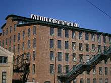
The older buildings were originally constructed in 1860 as part of the Passaic Zinc Works, with the later buildings constructed by Whitlock Cordage in and after 1905,[2] on a seven-acre site. Whitlock manufactured what many considered to be the world's strongest rope.[3]
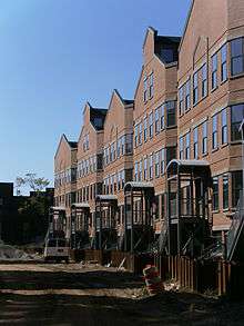
The building later became a sweatshop.[4] In 2003 a federal bankruptcy judge had ordered demolition of the property to allow for its resale. Ultimately, the Housing Trust of America agreed to purchase the property and preserve the structures.[3][5] The project included adaptive reuse of existing buildings as well as new construction and includes a total of 240 affordable and market rate apartments.[6][7]
The nearby Berry Lane Park is the largest municipal park, and was completed in 2016.
After years of delays the project resumed construction in September 2018.[8]
See also
| Wikimedia Commons has media related to Whitlock Cordage. |
References
- ↑ Karnoutsos, Carmela. "Whitlock Cordage/Whitlock MIlls". New Jersey City University. Retrieved 2013-06-16.
- ↑ Myers, Wiliam Starr (1945). Prominent Families of New Jersey. Genealogical Publishing Company. ISBN 9780806350363. Retrieved 2013-06-15.
- 1 2 "Whitlock Cordage". Jersey City Landmarks Campaign. April 24, 2011. Retrieved 2013-06-15.
- ↑ Glazer, Steven (November 3, 2003). "WHITLOCK CORDAGE KEEPS GETTING BETTER-FOR DEVELOPER". Urban Times News via Get NJ. Retrieved 2013-06-15.
- ↑ Antoinette, Martin (May 11, 2003). "A Significant Industrial Site Is Saved for Housing". The New York Times. Retrieved 2013-06-15.
- ↑ "Properties". Housing Trust of America. June 15, 2013. Retrieved 2013-06-15.
- ↑ Kelley, Donald M. (March 2003). "Historic industrial area to be redeveloped Some of Whitlock spared from demolition". Hudson Reporter. Retrieved 2013-06-15.
- ↑ https://www.nj.com/hudson/index.ssf/2018/09/jersey_city_officials_break_ground_on_affordable_h.html