White River Falls State Park
| White River Falls State Park | |
|---|---|
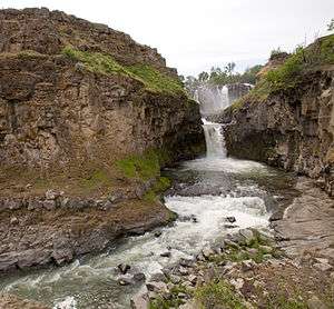 White River Falls is the upper 90 foot falls and Celestial Falls is the lower 44 foot falls dropping into the pool | |
 | |
| Type | Public, state |
| Location | Wasco County, Oregon, USA |
| Nearest city | Maupin |
| Coordinates | 45°14′29″N 121°05′44″W / 45.2415093°N 121.0956181°WCoordinates: 45°14′29″N 121°05′44″W / 45.2415093°N 121.0956181°W[1] |
| Operated by | Oregon Parks and Recreation Department |
| Open | mid-March through October |
White River Falls State Park is a state park in north central Oregon. It is located 35 miles (56 km) by road south of The Dalles and 4.5 miles (7.2 km) east of Tygh Valley.
The focus of the park is the falls where wild and scenic White River plunges 90 feet (27 m) from a basalt shelf. At the base of the falls are the ruins of a hydropower plant which supplied electricity to north central Oregon from 1910 to 1960.[2]
The falls are located at river mile (RM) 3 of the White River which flows into the Deschutes at RM 46.5.
There are no fees to use the park and is open mid-March through the end of October.[2]
See also
- ↑ "White River Falls State Park". Geographic Names Information System. United States Geological Survey. Retrieved 2008-11-24.
- 1 2 "White River Falls State Park". Oregon Parks and Recreation. Retrieved 2008-11-24.
[[USGS]http://geonames.usgs.gov/apex/f?p=136:3:0::NO:3:P3_FID%2CP3_TITLE:2770703%2CCelestial+Falls] [[USGS]http://geonames.usgs.gov/apex/f?p=136:3:0::NO::P3_FID,P3_TITLE:2770704,White%20River%20Falls]