White Horse Stone
The Upper and Lower White Horse Stones are names given to two sarsen megaliths on Blue Bell Hill near Aylesford in the English county of Kent. The Upper White Horse stone may be visited to this day, but the Lower White Horse Stone was destroyed in 1823.[1] The stones are considered to be fragmentary examples of the Neolithic chamber tomb group known as the Medway megaliths.
Upper White Horse Stone

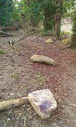
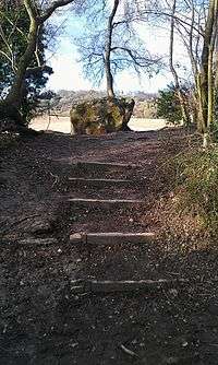
The Upper White Horse Stone (grid reference TQ753603) is 2.9 m long, 1.65 m high and about 0.6 m thick and stands just inside Westfield Wood, off the Pilgrims' Way. Close by it are nine smaller stones that stretch to the west for about 10 m.[1]
There is no evidence of a covering barrow and it has been suggested that these much smaller stones were moved from the neighbouring field by local farmers. Its identification as a chambered long barrow like the other Medway megaliths is therefore uncertain although the shape resembles a chamber wall stone.[1]
Lower White Horse Stone
The Lower White Horse Stone once stood about 300 m west of Upper White Horse Stone. It was destroyed in 1823 and the site is now under the dual carriageway that climbs Blue Bell Hill. It therefore cannot either be said with certainty to be a true prehistoric megalith.[1]
Folklore
Folkloric local stories have become attached to the White Horse Stones and nearby Kit's Coty House, related to a legendary 6th century battle between Anglo-Saxons led by Hengist and Horsa, and a British group led by Vortimer. The Anglo-Saxon chronicle records a battle at Aylesford (two miles from the site), but this, and other medieval sources, do not mention the stones.[2] In 1576, William Lambarde proposed that Kit's Coty House marked the grave of the British leader's brother, Categern, and suggested that Horsa's grave was located at the nearby village of Horsted.[3]
Lambarde's speculation was repeated in many guidebooks. Finally, in 1834, S C Lampreys imagined that the battle-standard of the Anglo-Saxons was laid on the White Horse Stone at the end of the battle.[4]
Historic England and Paul Ashbee note that the folkloric associations with the Upper White Horse Stone may have been transferred from the Lower White Horse Stone when it was destroyed.[1][5] Another theory for the name of the White Horse Stone is that it was named simply for resembling a horse.[1]
Local activism
On March 22, 1987 members of the Odinic Rite conducted "Operation Guardian" during which they cleared away undergrowth and built steps (which remain today) to allow access to the stone. The group called themselves Guardians of the White Horse Stone and looked after the area around the stone but activities were sporadic and unorganised. Citation needed
In 2004 the telecommunications company Orange sought planning permission to build a radio tower within just a few metres of the stone. Local residents contacted a religious group, The Odinic Rite, asking for their help as they had previously campaigned to have High Speed 1 diverted away from the stone. This group began a letter-writing campaign.[6] The council rejected the application.
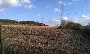
In May 2006 Orange sought planning permission from Maidstone Borough Council to install a telecommunications mast just across the border between the Maidstone and Tonbridge & Malling borough councils. This new proposal was still within 100 metres of the White Horse Stone and so a new campaign was launched by the Odinic Rite.
This application was refused on 28 July and the following reasons were given:
The proposed mast would be sited in a particular location that would intrude upon views across the Kent Downs Area of Outstanding Natural Beauty and the North Downs Special Landscape Area. In this respect this proposal would be harmful to the natural beauty and scenic quality of the landscape. Furthermore it would also be clearly visible from the North Downs Way and would affect the wider setting of the Ancient Monument for the White Horse Stone. The proposal would therefore be contrary to policies of the Maidstone Borough-Wide Local Plan 2000 and policies of the Kent and Medway Structure Plan 2006.
See also
References
- 1 2 3 4 5 6 "White Horse Stone, Aylesford". Historic England. Retrieved 10 September 2018.
- ↑ Anglo Saxon Chronicle (B) The Winchester Manuscript. See entry for year 455.
- ↑ Lambarde, William (1576). Perambulation of Kent.
- ↑ Lampreys, S C (1834). A Brief Historical and Descriptive Account of Maidstone and Its Environs.
- ↑ Ashbee, Paul (1993). "The Medway Megaliths in Perspective". Archaeologia Cantiana. 111: 86.
- ↑ Odinic Rite White Horse Stone campaigns
Bibliography
Ashbee, Paul (1993). "The Medway Megaliths in Perspective". Archaeologia Cantiana. Kent Archaeological Society. 111: 57–112.
External links
| Wikimedia Commons has media related to White Horse Stone. |
- The Megalithic Portal
- The Modern Antiquarian (Comments, news and photographs of the stone)
- White Horse Stone Campaign (An Odinic Rite campaign to prevent the construction of a telecommunications tower within yards of the stone.)
- Website of Guardians of the White Horse Stone. (A group set up by the Odinic Rite to protect the stone and surrounding area)