White Breast Creek
| White Breast Creek | |
| River | |
| Country | US |
|---|---|
| State | Iowa |
| Districts | Marion County, Iowa, Clarke County, Iowa, Lucas County, Iowa, Warren County, Iowa |
| Source | |
| - coordinates | 41°01′45″N 93°53′33″W / 41.0292°N 93.8924°W |
| Mouth | Des Moines River |
| - elevation | 725 ft (221 m) |
| - coordinates | 41°23′43″N 93°02′19″W / 41.3952°N 93.0385°WCoordinates: 41°23′43″N 93°02′19″W / 41.3952°N 93.0385°W |
 Mouth of White Breast Creek (United States Environmental Protection Agency) | |
| U.S. Geological Survey Geographic Names Information System: White Breast Creek | |
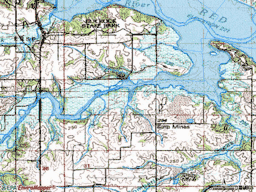
White Breast Creek is an important tributary of the Des Moines River in Iowa. It flows 91.3 miles (146.9 km)[1] from southwest to northeast, rising in Ward Township in Union County, near Osceola, and flowing in an easterly then a northeasterly direction, to its mouth with the Des Moines River at Lake Red Rock.
Tributaries
Its first main tributary is South White Breast Creek, on its left bank; this creek has intermittent tributaries named Hoosier Creek and Little Hoosier Creek in Green Bay Township in Clarke County.
Brush Creek enters as a right bank tributary south of Lucas, in the Lucas Unit of the Stephens State Forest Wildlife Management Area, in Jackson Township of Lucas County. Indian Creek (White Breast Creek) joins in Liberty Township, also on the left bank.
Little White Breast Creek enters from the right bank, also in Liberty Township in Lucas County. This creek rises north and east of Chariton from Lake Morris and Lake Ellis, two small reservoirs.
The next three left bank tributaries are Barker Creek (White Breast Creek), a short stream confined to Liberty Township in Lucas County; Stoney Creek (White Breast Creek) then Cotton Creek (White Breast Creek) join White Breast Creek near Lacona.
Wolf Creek (White Breast Creek) and its tributary, Flank Creek (White Breast Creek) enter on the left bank in Dallas Township, a few miles west of Dallas. A few miles north of Dallas, the creek has a significant floodplain, regularly subject to inundation.
Hawk Run (White Breast Creek) is the last significant tributary, entering near Lake Red Rock on the left bank.
You should probably add Wind Branch which enters from the right about 3 1/2 miles south of Lacona. And though it nearly runs dry, it comes out in a hurry with a substantial rain. Takes about 2" in a short time to bring it out (over the flat bridge on paved State Road 69. Wind Branch drains the hills going up to Newburn. Town of few people (today, as opposed to the turn of last century), last I knew it had a ballfield. Believe it died because railroad never came through like surviving communities of Lacona and Milo, both Warren County. Also, doesn't likely have a paved road either.
 The county line dirt road (bordering Warren and Marion Counties, west of Wind Branch creek in Warren before the bridge And east of it on the Marion County side) used to run across the floodplain/bottomlands till hurricane Ivan came up the Mississippi Valley in 2005. It was never rebuilt. The road over White Breast was as it is paved and state road and a major artery to Knoxville.
 Of interest, to me at least, are a few other items. One is Bauer. What's left of it sets on the highest hill above the conjunction of Wind Branch and White Breast. Basically a Catholic church, school, and cemetery, a couple houses yet, I think. Not likely ever incorporated, I think. Plus the top of the hills above "the old channel" had Indian burial mounds and likely a large settlement nearby. Apparently still there during the early settlement period of white immigrants. Maybe e historical society will check me out on this.Only know I found a few arrow heads in Wind Branch and that people would search the bottomlands for them and other artifacts after spring plowing.
 Back to the "od channel"; it was on our bottom, Marion County side. Before the work during and after the Great Depression, the tortuous path of White Breast where Wind Branch came in was straightened. Though still fills with water every time White Breast comes out. Drains through the field tiles eventually. But not before the fishing in it gets good. As far as the rest of the Marion County/ White Breast/ Wind Branch bottom, ever go hand fishing in rows of standing corn?
 Long story, but who is going to look here but those who know I am by now? Bob Metz S.E. Warren H.S. graduate 1974 - 1975. Maybe someone will from there will edit this or add their two cents, possible see if a local historical society is interested.
Finishing now, but there is a (usually) small stream that is between White Breast and Wind Branch to the west, and also entering from the right. Even I don't know if it has a name. It's big enough to warrant two bridges rather than culverts. Also, it drains Oak Ridge so can have to haul a lot of water in a hurry in a downpour.
 Then there is Chicago bridge (if it's still there), believe the former site of a long gone mill, and there's still remnants of foundations of long gone Chicago, Iowa. Good fishing spot, creek drops fast (I believe still), and east of Wolf Creek. On its way to Red Rock. 'bout as far as my travels when young, on foot. Even better spot closer to Red Rock and its exceptional ( at that time ) bridge.
 Don't need sources. If you've read this, you know the farm bordered White Breast and Wind Branch and the county lines of Warren and Marion. In south-central Iowa.
See also
References
- ↑ U.S. Geological Survey. National Hydrography Dataset high-resolution flowline data. The National Map, accessed May 26, 2011